You are here: Home > Network List > BK - Berkeley Digital Seismograph Network Stations List
> Station FARB Farallon Islands, CA > Earthquake Result Viewer
FARB Farallon Islands, CA - Earthquake Result Viewer
| Earthquake location: |
New Ireland Region, P.N.G. |
| Earthquake latitude/longitude: |
-4.5/153.5 |
| Earthquake time(UTC): |
2005/09/09 (252) 07:26:43 GMT |
| Earthquake Depth: |
90 km |
| Earthquake Magnitude: |
6.3 MB, 7.7 MW, 7.5 MW |
| Earthquake Catalog/Contributor: |
WHDF/NEIC |
|
| Network: |
BK Berkeley Digital Seismograph Network |
| Station: |
FARB Farallon Islands, CA |
| Lat/Lon: |
37.70 N/123.00 W |
| Elevation: |
-18.5 m |
|
| Distance: |
87.6 deg |
| Az: |
52.077 deg |
| Baz: |
262.477 deg |
| Ray Param: |
0.043000177 |
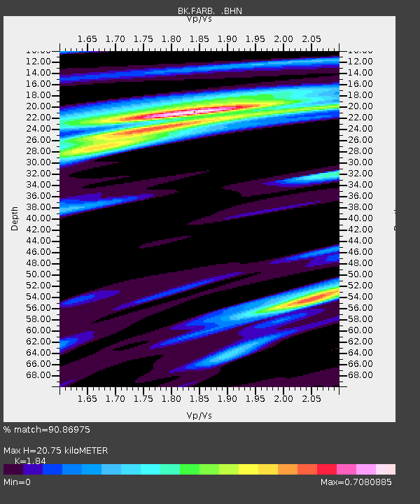
| Estimated Moho Depth: |
20.75 km |
| Estimated Crust Vp/Vs: |
1.84 |
| Assumed Crust Vp: |
6.183 km/s |
| Estimated Crust Vs: |
3.36 km/s |
| Estimated Crust Poisson's Ratio: |
0.29 |
|
| Radial Match: |
90.86975 % |
| Radial Bump: |
221 |
| Transverse Match: |
77.07791 % |
| Transverse Bump: |
400 |
| SOD ConfigId: |
2475 |
| Insert Time: |
2010-03-05 19:16:03.942 +0000 |
| GWidth: |
2.5 |
| Max Bumps: |
400 |
| Tol: |
0.001 |
|
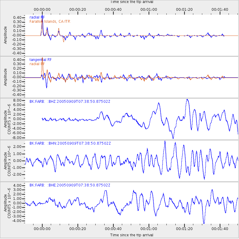
Signal To Noise
| Channel | StoN | STA | LTA |
| BK:FARB: :BHN:20050909T07:38:50.87502Z | 0.9355275 | 4.1846906E-7 | 4.4730814E-7 |
| BK:FARB: :BHE:20050909T07:38:50.87502Z | 2.2465355 | 6.19084E-7 | 2.7557277E-7 |
| BK:FARB: :BHZ:20050909T07:38:50.87502Z | 5.756733 | 1.7341018E-6 | 3.012302E-7 |
| Arrivals |
| Ps | 2.9 SECOND |
| PpPs | 9.3 SECOND |
| PsPs/PpSs | 12 SECOND |


