You are here: Home > Network List > BK - Berkeley Digital Seismograph Network Stations List
> Station FARB Farallon Islands, CA > Earthquake Result Viewer
FARB Farallon Islands, CA - Earthquake Result Viewer
| Earthquake location: |
South Of Fiji Islands |
| Earthquake latitude/longitude: |
-25.8/179.5 |
| Earthquake time(UTC): |
2007/10/16 (289) 21:05:43 GMT |
| Earthquake Depth: |
509 km |
| Earthquake Magnitude: |
6.2 MB, 6.6 MW, 6.5 MW |
| Earthquake Catalog/Contributor: |
WHDF/NEIC |
|
| Network: |
BK Berkeley Digital Seismograph Network |
| Station: |
FARB Farallon Islands, CA |
| Lat/Lon: |
37.70 N/123.00 W |
| Elevation: |
-18.5 m |
|
| Distance: |
83.0 deg |
| Az: |
42.357 deg |
| Baz: |
229.981 deg |
| Ray Param: |
0.045009088 |
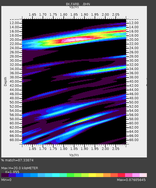
| Estimated Moho Depth: |
20.0 km |
| Estimated Crust Vp/Vs: |
1.86 |
| Assumed Crust Vp: |
6.183 km/s |
| Estimated Crust Vs: |
3.333 km/s |
| Estimated Crust Poisson's Ratio: |
0.30 |
|
| Radial Match: |
87.33874 % |
| Radial Bump: |
362 |
| Transverse Match: |
75.74944 % |
| Transverse Bump: |
318 |
| SOD ConfigId: |
2564 |
| Insert Time: |
2010-03-05 19:16:13.675 +0000 |
| GWidth: |
2.5 |
| Max Bumps: |
400 |
| Tol: |
0.001 |
|
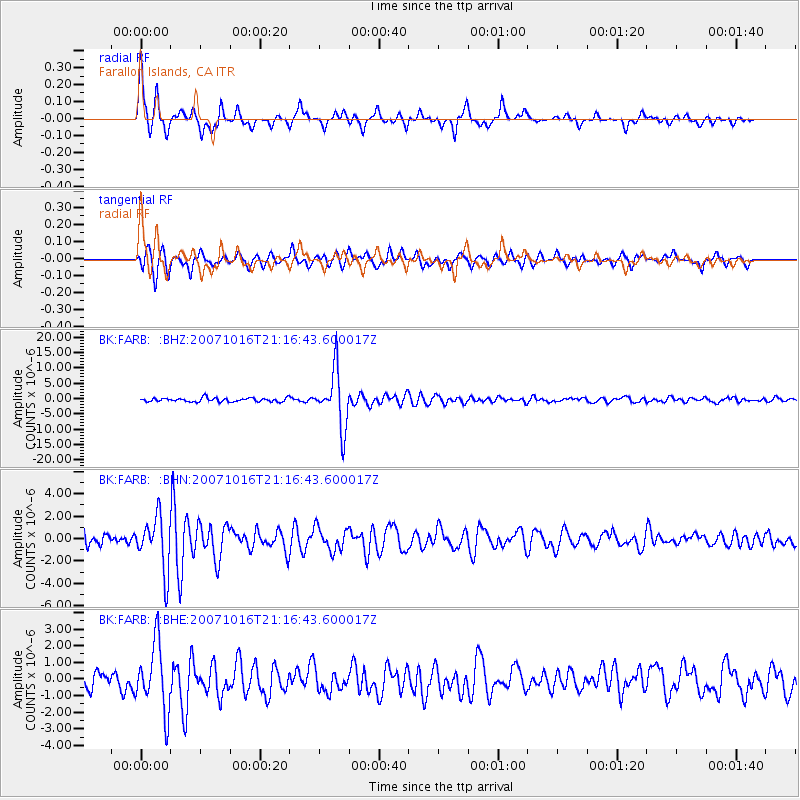
Signal To Noise
| Channel | StoN | STA | LTA |
| BK:FARB: :BHN:20071016T21:16:43.600017Z | 4.1966934 | 2.3736254E-6 | 5.655942E-7 |
| BK:FARB: :BHE:20071016T21:16:43.600017Z | 3.883026 | 2.000351E-6 | 5.1515264E-7 |
| BK:FARB: :BHZ:20071016T21:16:43.600017Z | 14.97333 | 9.0843205E-6 | 6.067001E-7 |
| Arrivals |
| Ps | 2.8 SECOND |
| PpPs | 9.0 SECOND |
| PsPs/PpSs | 12 SECOND |


