You are here: Home > Network List > BK - Berkeley Digital Seismograph Network Stations List
> Station FARB Farallon Islands, CA > Earthquake Result Viewer
FARB Farallon Islands, CA - Earthquake Result Viewer
| Earthquake location: |
South Of Mariana Islands |
| Earthquake latitude/longitude: |
10.5/145.7 |
| Earthquake time(UTC): |
2007/09/30 (273) 02:08:30 GMT |
| Earthquake Depth: |
14 km |
| Earthquake Magnitude: |
6.4 MB, 7.1 MS, 6.9 MW, 6.9 MW |
| Earthquake Catalog/Contributor: |
WHDF/NEIC |
|
| Network: |
BK Berkeley Digital Seismograph Network |
| Station: |
FARB Farallon Islands, CA |
| Lat/Lon: |
37.70 N/123.00 W |
| Elevation: |
-18.5 m |
|
| Distance: |
84.7 deg |
| Az: |
52.791 deg |
| Baz: |
279.036 deg |
| Ray Param: |
0.045286067 |
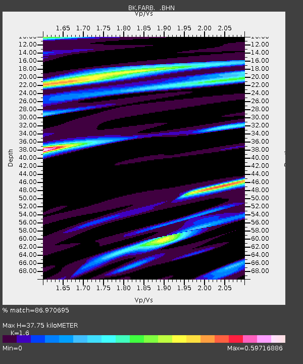
| Estimated Moho Depth: |
37.75 km |
| Estimated Crust Vp/Vs: |
1.60 |
| Assumed Crust Vp: |
6.183 km/s |
| Estimated Crust Vs: |
3.864 km/s |
| Estimated Crust Poisson's Ratio: |
0.18 |
|
| Radial Match: |
86.970695 % |
| Radial Bump: |
400 |
| Transverse Match: |
78.30972 % |
| Transverse Bump: |
400 |
| SOD ConfigId: |
2564 |
| Insert Time: |
2010-03-05 19:16:15.761 +0000 |
| GWidth: |
2.5 |
| Max Bumps: |
400 |
| Tol: |
0.001 |
|
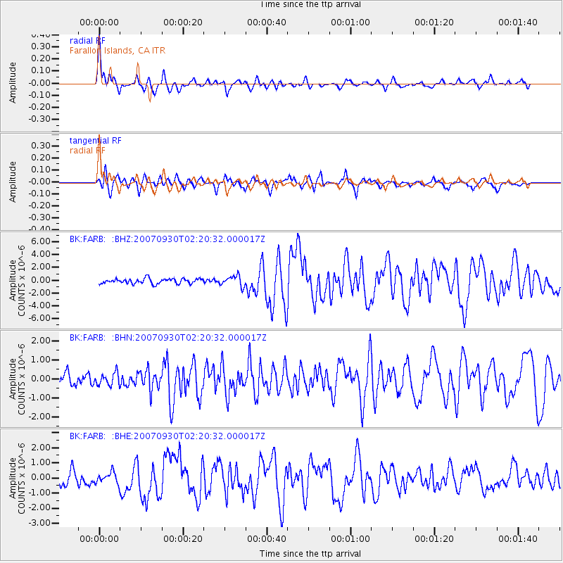
Signal To Noise
| Channel | StoN | STA | LTA |
| BK:FARB: :BHN:20070930T02:20:32.000017Z | 1.013898 | 3.2619025E-7 | 3.2171897E-7 |
| BK:FARB: :BHE:20070930T02:20:32.000017Z | 1.1103077 | 3.6365142E-7 | 3.275231E-7 |
| BK:FARB: :BHZ:20070930T02:20:32.000017Z | 2.124869 | 8.2808793E-7 | 3.8971245E-7 |
| Arrivals |
| Ps | 3.8 SECOND |
| PpPs | 15 SECOND |
| PsPs/PpSs | 19 SECOND |


