You are here: Home > Network List > BK - Berkeley Digital Seismograph Network Stations List
> Station FARB Farallon Islands, CA > Earthquake Result Viewer
FARB Farallon Islands, CA - Earthquake Result Viewer
| Earthquake location: |
Central Mid-Atlantic Ridge |
| Earthquake latitude/longitude: |
8.0/-39.2 |
| Earthquake time(UTC): |
2007/08/20 (232) 22:42:29 GMT |
| Earthquake Depth: |
10 km |
| Earthquake Magnitude: |
6.3 MB, 6.4 MS, 6.5 MW |
| Earthquake Catalog/Contributor: |
WHDF/NEIC |
|
| Network: |
BK Berkeley Digital Seismograph Network |
| Station: |
FARB Farallon Islands, CA |
| Lat/Lon: |
37.70 N/123.00 W |
| Elevation: |
-18.5 m |
|
| Distance: |
80.2 deg |
| Az: |
306.853 deg |
| Baz: |
87.408 deg |
| Ray Param: |
0.048433345 |
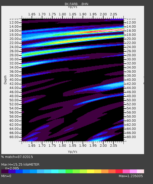
| Estimated Moho Depth: |
15.25 km |
| Estimated Crust Vp/Vs: |
2.09 |
| Assumed Crust Vp: |
6.183 km/s |
| Estimated Crust Vs: |
2.965 km/s |
| Estimated Crust Poisson's Ratio: |
0.35 |
|
| Radial Match: |
87.82015 % |
| Radial Bump: |
400 |
| Transverse Match: |
74.37046 % |
| Transverse Bump: |
400 |
| SOD ConfigId: |
2564 |
| Insert Time: |
2010-03-05 19:16:26.962 +0000 |
| GWidth: |
2.5 |
| Max Bumps: |
400 |
| Tol: |
0.001 |
|
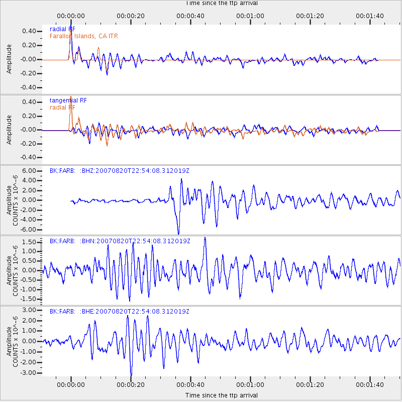
Signal To Noise
| Channel | StoN | STA | LTA |
| BK:FARB: :BHN:20070820T22:54:08.312019Z | 0.8362924 | 2.5454332E-7 | 3.0437118E-7 |
| BK:FARB: :BHE:20070820T22:54:08.312019Z | 1.590373 | 3.839062E-7 | 2.4139382E-7 |
| BK:FARB: :BHZ:20070820T22:54:08.312019Z | 5.191331 | 1.0169093E-6 | 1.9588605E-7 |
| Arrivals |
| Ps | 2.7 SECOND |
| PpPs | 7.4 SECOND |
| PsPs/PpSs | 10 SECOND |


