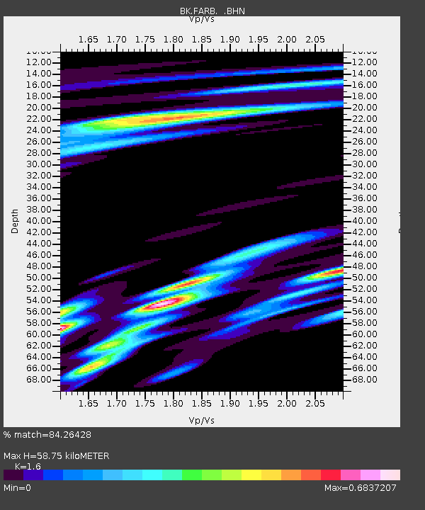
FARB Farallon Islands, CA - Earthquake Result Viewer
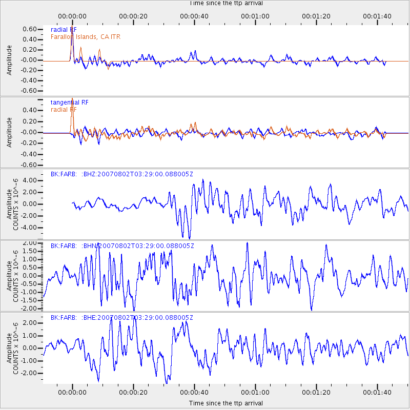
Earthquake location: Andreanof Islands, Aleutian Is.
Earthquake latitude/longitude: 51.3/-180.0
Earthquake time(UTC): 2007/08/02 (214) 03:21:42 GMT
Earthquake Depth: 21 km
Earthquake Magnitude: 6.3 MB, 6.6 MS, 6.7 MW, 6.6 MW
Earthquake Catalog/Contributor: WHDF/NEIC
Network: BK Berkeley Digital Seismograph Network
Station: FARB Farallon Islands, CA
Lat/Lon: 37.70 N/123.00 W
Elevation: -18.5 m
Distance: 41.8 deg
Az: 86.074 deg
Baz: 307.864 deg
Ray Param: 0.07352902
Estimated Moho Depth: 58.75 km
Estimated Crust Vp/Vs: 1.60
Assumed Crust Vp: 6.183 km/s
Estimated Crust Vs: 3.864 km/s
Estimated Crust Poisson's Ratio: 0.18
Radial Match: 84.26428 %
Radial Bump: 388
Transverse Match: 64.036606 %
Transverse Bump: 400
SOD ConfigId: 2564
Insert Time: 2010-03-05 19:16:33.446 +0000
GWidth: 2.5
Max Bumps: 400
Tol: 0.001

Signal To Noise

ChannelStoNSTALTA
BK:FARB: :BHN:20070802T03:29:00.088005Z0.996742845.324589E-75.341989E-7
BK:FARB: :BHE:20070802T03:29:00.088005Z1.03017665.254681E-75.100757E-7
BK:FARB: :BHZ:20070802T03:29:00.088005Z2.22039941.366379E-66.1537537E-7
Arrivals
Ps6.1 SECOND
PpPs23 SECOND
PsPs/PpSs29 SECOND