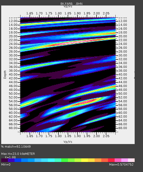
FARB Farallon Islands, CA - Earthquake Result Viewer
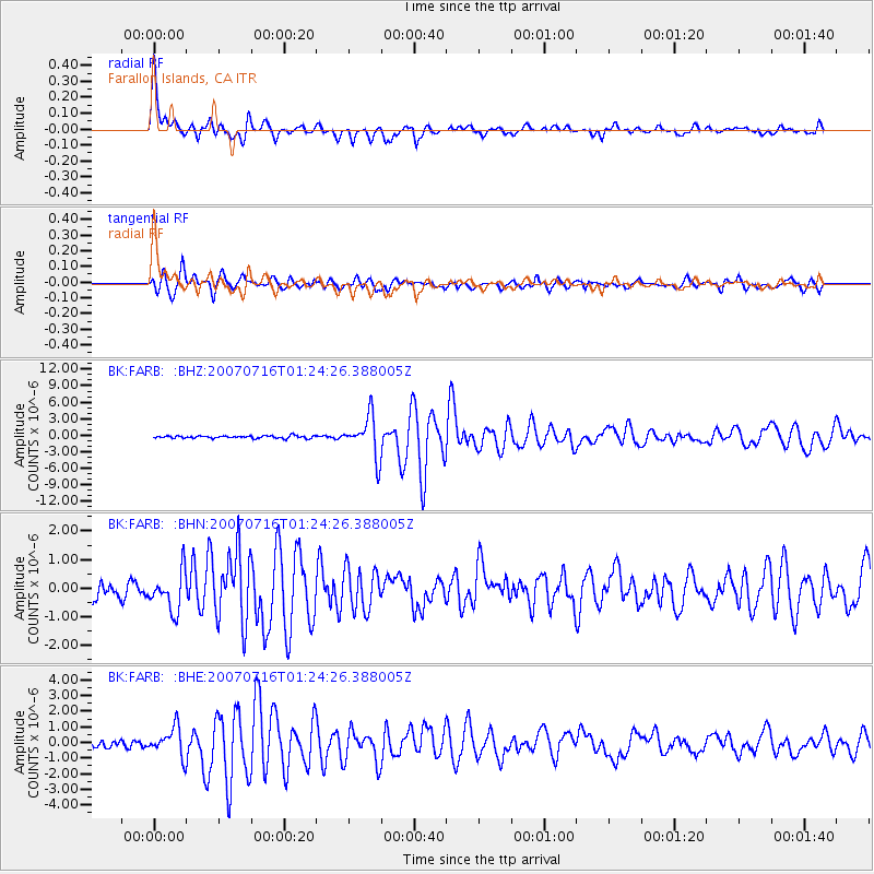
Earthquake location: Near West Coast Of Honshu, Japan
Earthquake latitude/longitude: 37.5/138.4
Earthquake time(UTC): 2007/07/16 (197) 01:13:22 GMT
Earthquake Depth: 12 km
Earthquake Magnitude: 6.5 MB, 6.4 MS, 6.6 MW, 6.5 MW
Earthquake Catalog/Contributor: WHDF/NEIC
Network: BK Berkeley Digital Seismograph Network
Station: FARB Farallon Islands, CA
Lat/Lon: 37.70 N/123.00 W
Elevation: -18.5 m
Distance: 74.0 deg
Az: 54.688 deg
Baz: 305.136 deg
Ray Param: 0.05262403
Estimated Moho Depth: 23.0 km
Estimated Crust Vp/Vs: 1.88
Assumed Crust Vp: 6.183 km/s
Estimated Crust Vs: 3.289 km/s
Estimated Crust Poisson's Ratio: 0.30
Radial Match: 92.10649 %
Radial Bump: 355
Transverse Match: 87.799095 %
Transverse Bump: 400
SOD ConfigId: 2564
Insert Time: 2010-03-05 19:16:38.697 +0000
GWidth: 2.5
Max Bumps: 400
Tol: 0.001

Signal To Noise

ChannelStoNSTALTA
BK:FARB: :BHN:20070716T01:24:26.388005Z2.8871146.8516465E-72.3731818E-7
BK:FARB: :BHE:20070716T01:24:26.388005Z3.76842559.073441E-72.407754E-7
BK:FARB: :BHZ:20070716T01:24:26.388005Z16.1648943.6718418E-62.2714914E-7
Arrivals
Ps3.4 SECOND
PpPs10 SECOND
PsPs/PpSs14 SECOND