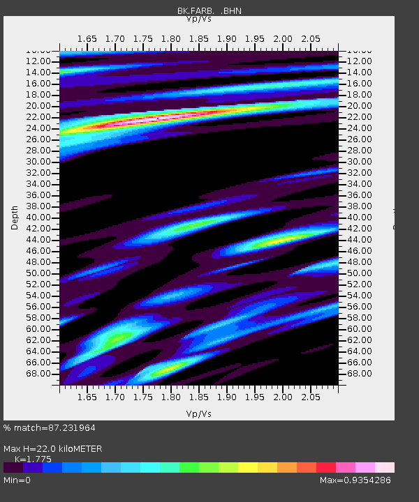
FARB Farallon Islands, CA - Earthquake Result Viewer
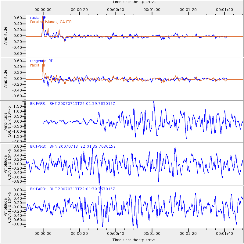
Earthquake location: Andreanof Islands, Aleutian Is.
Earthquake latitude/longitude: 51.8/-176.3
Earthquake time(UTC): 2007/07/13 (194) 21:54:43 GMT
Earthquake Depth: 35 km
Earthquake Magnitude: 5.7 MB, 5.6 MS, 6.0 MW, 5.9 MW
Earthquake Catalog/Contributor: WHDF/NEIC
Network: BK Berkeley Digital Seismograph Network
Station: FARB Farallon Islands, CA
Lat/Lon: 37.70 N/123.00 W
Elevation: -18.5 m
Distance: 39.5 deg
Az: 89.473 deg
Baz: 308.542 deg
Ray Param: 0.07488947
Estimated Moho Depth: 22.0 km
Estimated Crust Vp/Vs: 1.77
Assumed Crust Vp: 6.183 km/s
Estimated Crust Vs: 3.483 km/s
Estimated Crust Poisson's Ratio: 0.27
Radial Match: 87.231964 %
Radial Bump: 344
Transverse Match: 75.78476 %
Transverse Bump: 387
SOD ConfigId: 2564
Insert Time: 2010-03-05 19:16:46.287 +0000
GWidth: 2.5
Max Bumps: 400
Tol: 0.001

Signal To Noise

ChannelStoNSTALTA
BK:FARB: :BHN:20070713T22:01:39.763015Z2.03719882.3512443E-71.1541555E-7
BK:FARB: :BHE:20070713T22:01:39.763015Z1.54576291.7656657E-71.1422617E-7
BK:FARB: :BHZ:20070713T22:01:39.763015Z4.16070134.91492E-71.18127204E-7
Arrivals
Ps2.9 SECOND
PpPs9.3 SECOND
PsPs/PpSs12 SECOND