You are here: Home > Network List > CN - Canadian National Seismograph Network Stations List
> Station INK INUVIK, NT > Earthquake Result Viewer
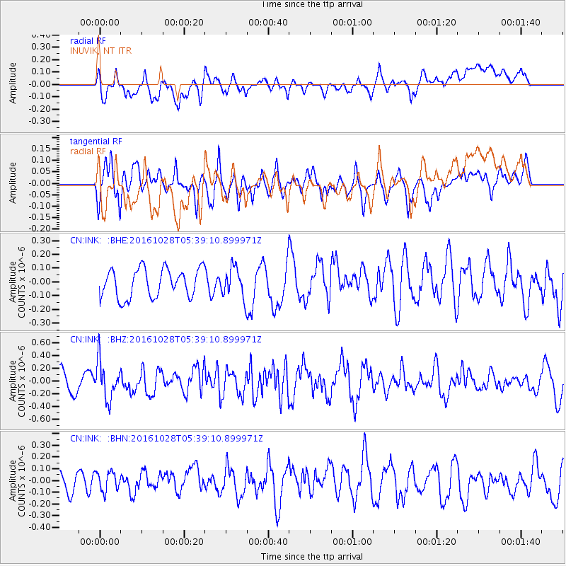
INK INUVIK, NT - Earthquake Result Viewer
*The percent match for this event was below the threshold and hence no stack was calculated.
| Earthquake location: |
New Ireland Region, P.N.G. |
| Earthquake latitude/longitude: |
-4.7/153.2 |
| Earthquake time(UTC): |
2016/10/28 (302) 05:26:57 GMT |
| Earthquake Depth: |
61 km |
| Earthquake Magnitude: |
5.7 MB |
| Earthquake Catalog/Contributor: |
NEIC PDE/NEIC COMCAT |
|
| Network: |
CN Canadian National Seismograph Network |
| Station: |
INK INUVIK, NT |
| Lat/Lon: |
68.31 N/133.53 W |
| Elevation: |
44 m |
|
| Distance: |
88.2 deg |
| Az: |
20.874 deg |
| Baz: |
252.78 deg |
| Ray Param: |
$rayparam |
*The percent match for this event was below the threshold and hence was not used in the summary stack. |
|
| Radial Match: |
56.22173 % |
| Radial Bump: |
400 |
| Transverse Match: |
64.835396 % |
| Transverse Bump: |
400 |
| SOD ConfigId: |
11737051 |
| Insert Time: |
2019-04-25 23:09:08.178 +0000 |
| GWidth: |
2.5 |
| Max Bumps: |
400 |
| Tol: |
0.001 |
|
Signal To Noise
| Channel | StoN | STA | LTA |
| CN:INK: :BHZ:20161028T05:39:10.899971Z | 2.0511062 | 2.990599E-7 | 1.4580421E-7 |
| CN:INK: :BHN:20161028T05:39:10.899971Z | 0.8517725 | 8.686415E-8 | 1.01980454E-7 |
| CN:INK: :BHE:20161028T05:39:10.899971Z | 1.190291 | 1.2345126E-7 | 1.03715195E-7 |
| Arrivals |
| Ps | |
| PpPs | |
| PsPs/PpSs | |


