You are here: Home > Network List > GS - US Geological Survey Networks Stations List
> Station KAN10 Keim Farm, Anthony, KS, USA > Earthquake Result Viewer
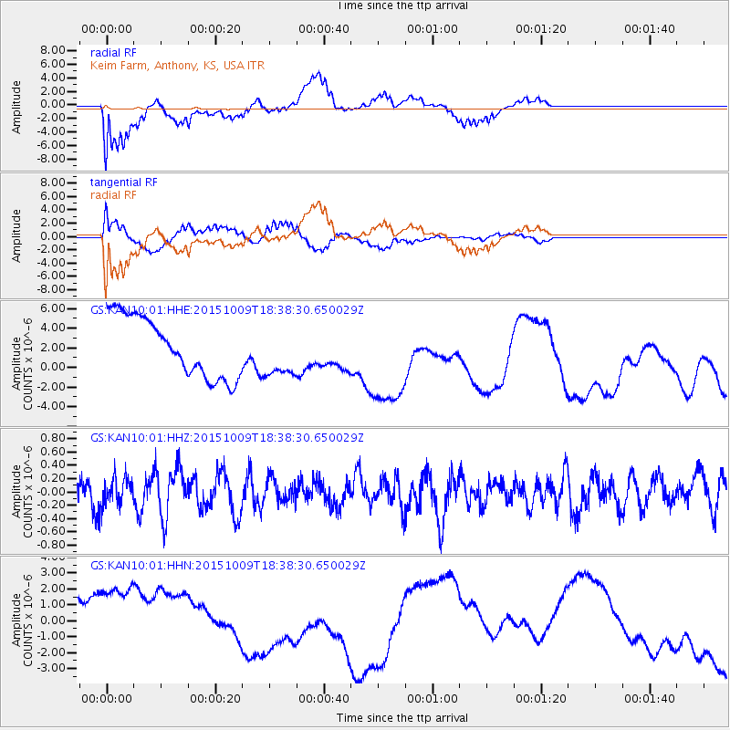
KAN10 Keim Farm, Anthony, KS, USA - Earthquake Result Viewer
*The percent match for this event was below the threshold and hence no stack was calculated.
| Earthquake location: |
Near Coast Of Central Chile |
| Earthquake latitude/longitude: |
-31.7/-71.7 |
| Earthquake time(UTC): |
2015/10/09 (282) 18:27:36 GMT |
| Earthquake Depth: |
35 km |
| Earthquake Magnitude: |
5.5 MWW, 5.4 MWR, 5.4 MWB |
| Earthquake Catalog/Contributor: |
NEIC PDE/NEIC COMCAT |
|
| Network: |
GS US Geological Survey Networks |
| Station: |
KAN10 Keim Farm, Anthony, KS, USA |
| Lat/Lon: |
37.12 N/98.10 W |
| Elevation: |
417 m |
|
| Distance: |
72.8 deg |
| Az: |
338.193 deg |
| Baz: |
156.671 deg |
| Ray Param: |
$rayparam |
*The percent match for this event was below the threshold and hence was not used in the summary stack. |
|
| Radial Match: |
60.154366 % |
| Radial Bump: |
400 |
| Transverse Match: |
53.162773 % |
| Transverse Bump: |
400 |
| SOD ConfigId: |
1156111 |
| Insert Time: |
2015-10-23 18:42:54.443 +0000 |
| GWidth: |
2.5 |
| Max Bumps: |
400 |
| Tol: |
0.001 |
|
Signal To Noise
| Channel | StoN | STA | LTA |
| GS:KAN10:01:HHZ:20151009T18:38:30.650029Z | 0.82299525 | 1.929551E-7 | 2.344547E-7 |
| GS:KAN10:01:HHN:20151009T18:38:30.650029Z | 1.79608 | 4.0686045E-6 | 2.265269E-6 |
| GS:KAN10:01:HHE:20151009T18:38:30.650029Z | 0.83483386 | 2.5502316E-6 | 3.0547772E-6 |
| Arrivals |
| Ps | |
| PpPs | |
| PsPs/PpSs | |


