You are here: Home > Network List > TA - USArray Transportable Network (new EarthScope stations) Stations List
> Station D23K Nanushuk River, AK USA > Earthquake Result Viewer
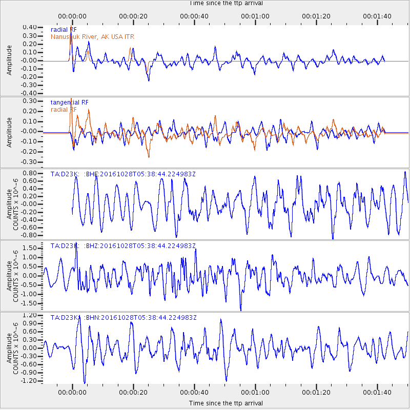
D23K Nanushuk River, AK USA - Earthquake Result Viewer
*The percent match for this event was below the threshold and hence no stack was calculated.
| Earthquake location: |
New Ireland Region, P.N.G. |
| Earthquake latitude/longitude: |
-4.7/153.2 |
| Earthquake time(UTC): |
2016/10/28 (302) 05:26:57 GMT |
| Earthquake Depth: |
61 km |
| Earthquake Magnitude: |
5.7 MB |
| Earthquake Catalog/Contributor: |
NEIC PDE/NEIC COMCAT |
|
| Network: |
TA USArray Transportable Network (new EarthScope stations) |
| Station: |
D23K Nanushuk River, AK USA |
| Lat/Lon: |
68.97 N/150.68 W |
| Elevation: |
406 m |
|
| Distance: |
82.9 deg |
| Az: |
17.592 deg |
| Baz: |
236.547 deg |
| Ray Param: |
$rayparam |
*The percent match for this event was below the threshold and hence was not used in the summary stack. |
|
| Radial Match: |
49.082184 % |
| Radial Bump: |
377 |
| Transverse Match: |
61.0179 % |
| Transverse Bump: |
400 |
| SOD ConfigId: |
11737051 |
| Insert Time: |
2019-04-25 23:11:20.977 +0000 |
| GWidth: |
2.5 |
| Max Bumps: |
400 |
| Tol: |
0.001 |
|
Signal To Noise
| Channel | StoN | STA | LTA |
| TA:D23K: :BHZ:20161028T05:38:44.224983Z | 1.5876335 | 6.640129E-7 | 4.1824066E-7 |
| TA:D23K: :BHN:20161028T05:38:44.224983Z | 2.5461361 | 7.2096816E-7 | 2.8316165E-7 |
| TA:D23K: :BHE:20161028T05:38:44.224983Z | 1.2512108 | 4.555576E-7 | 3.640934E-7 |
| Arrivals |
| Ps | |
| PpPs | |
| PsPs/PpSs | |


