You are here: Home > Network List > TA - USArray Transportable Network (new EarthScope stations) Stations List
> Station D25K Kavik River, AK, USA > Earthquake Result Viewer
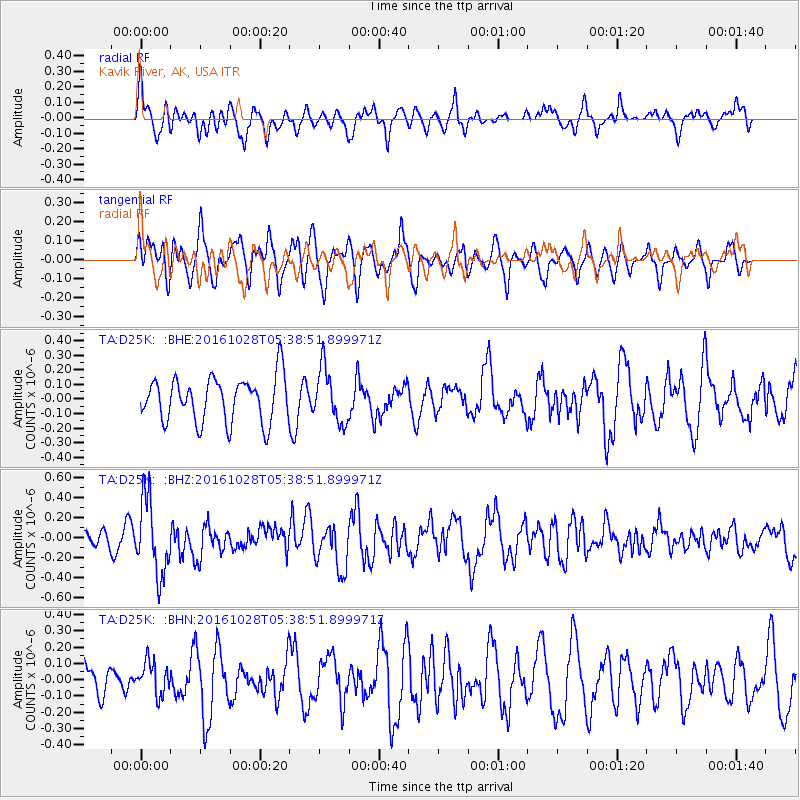
D25K Kavik River, AK, USA - Earthquake Result Viewer
*The percent match for this event was below the threshold and hence no stack was calculated.
| Earthquake location: |
New Ireland Region, P.N.G. |
| Earthquake latitude/longitude: |
-4.7/153.2 |
| Earthquake time(UTC): |
2016/10/28 (302) 05:26:57 GMT |
| Earthquake Depth: |
61 km |
| Earthquake Magnitude: |
5.7 MB |
| Earthquake Catalog/Contributor: |
NEIC PDE/NEIC COMCAT |
|
| Network: |
TA USArray Transportable Network (new EarthScope stations) |
| Station: |
D25K Kavik River, AK, USA |
| Lat/Lon: |
69.32 N/146.38 W |
| Elevation: |
770 m |
|
| Distance: |
84.4 deg |
| Az: |
18.093 deg |
| Baz: |
240.623 deg |
| Ray Param: |
$rayparam |
*The percent match for this event was below the threshold and hence was not used in the summary stack. |
|
| Radial Match: |
56.949665 % |
| Radial Bump: |
400 |
| Transverse Match: |
56.420002 % |
| Transverse Bump: |
400 |
| SOD ConfigId: |
11737051 |
| Insert Time: |
2019-04-25 23:11:21.472 +0000 |
| GWidth: |
2.5 |
| Max Bumps: |
400 |
| Tol: |
0.001 |
|
Signal To Noise
| Channel | StoN | STA | LTA |
| TA:D25K: :BHZ:20161028T05:38:51.899971Z | 3.007173 | 3.7482363E-7 | 1.2464318E-7 |
| TA:D25K: :BHN:20161028T05:38:51.899971Z | 0.6484571 | 1.0052633E-7 | 1.5502387E-7 |
| TA:D25K: :BHE:20161028T05:38:51.899971Z | 1.2133621 | 1.8594015E-7 | 1.5324375E-7 |
| Arrivals |
| Ps | |
| PpPs | |
| PsPs/PpSs | |


