You are here: Home > Network List > TA - USArray Transportable Network (new EarthScope stations) Stations List
> Station I23K Minto, Yukon-Koyukuk, AK, USA > Earthquake Result Viewer
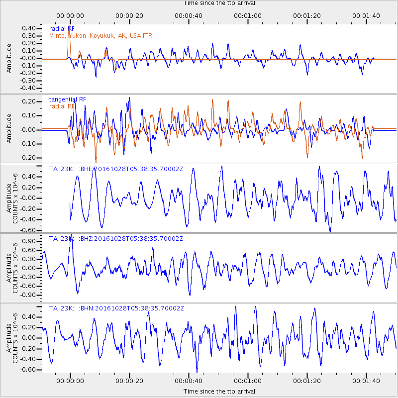
I23K Minto, Yukon-Koyukuk, AK, USA - Earthquake Result Viewer
*The percent match for this event was below the threshold and hence no stack was calculated.
| Earthquake location: |
New Ireland Region, P.N.G. |
| Earthquake latitude/longitude: |
-4.7/153.2 |
| Earthquake time(UTC): |
2016/10/28 (302) 05:26:57 GMT |
| Earthquake Depth: |
61 km |
| Earthquake Magnitude: |
5.7 MB |
| Earthquake Catalog/Contributor: |
NEIC PDE/NEIC COMCAT |
|
| Network: |
TA USArray Transportable Network (new EarthScope stations) |
| Station: |
I23K Minto, Yukon-Koyukuk, AK, USA |
| Lat/Lon: |
65.15 N/149.36 W |
| Elevation: |
149 m |
|
| Distance: |
81.2 deg |
| Az: |
21.136 deg |
| Baz: |
238.253 deg |
| Ray Param: |
$rayparam |
*The percent match for this event was below the threshold and hence was not used in the summary stack. |
|
| Radial Match: |
58.211773 % |
| Radial Bump: |
400 |
| Transverse Match: |
40.468037 % |
| Transverse Bump: |
400 |
| SOD ConfigId: |
11737051 |
| Insert Time: |
2019-04-25 23:11:41.273 +0000 |
| GWidth: |
2.5 |
| Max Bumps: |
400 |
| Tol: |
0.001 |
|
Signal To Noise
| Channel | StoN | STA | LTA |
| TA:I23K: :BHZ:20161028T05:38:35.70002Z | 2.461424 | 5.8505503E-7 | 2.3768965E-7 |
| TA:I23K: :BHN:20161028T05:38:35.70002Z | 0.40383482 | 8.7490434E-8 | 2.1664907E-7 |
| TA:I23K: :BHE:20161028T05:38:35.70002Z | 0.8008446 | 2.0579111E-7 | 2.5696758E-7 |
| Arrivals |
| Ps | |
| PpPs | |
| PsPs/PpSs | |


