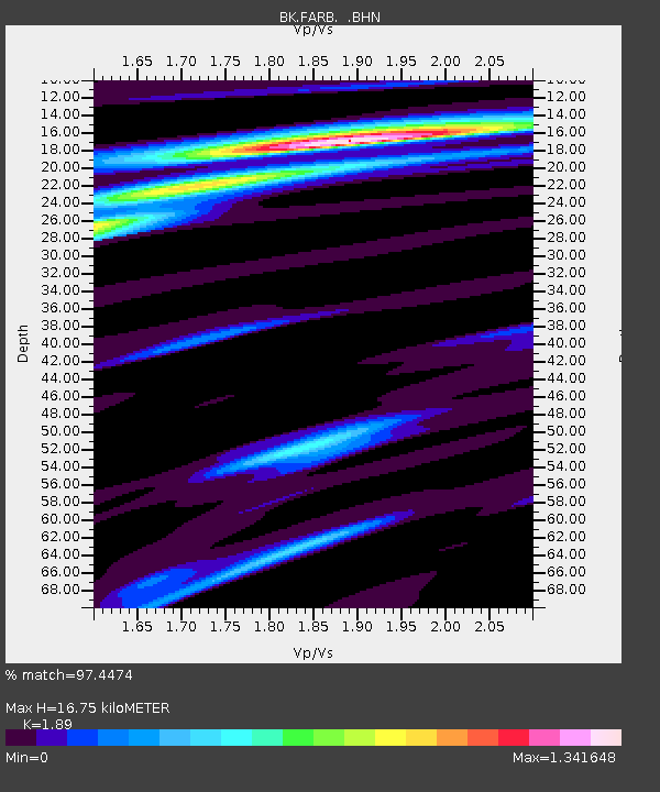
FARB Farallon Islands, CA - Earthquake Result Viewer
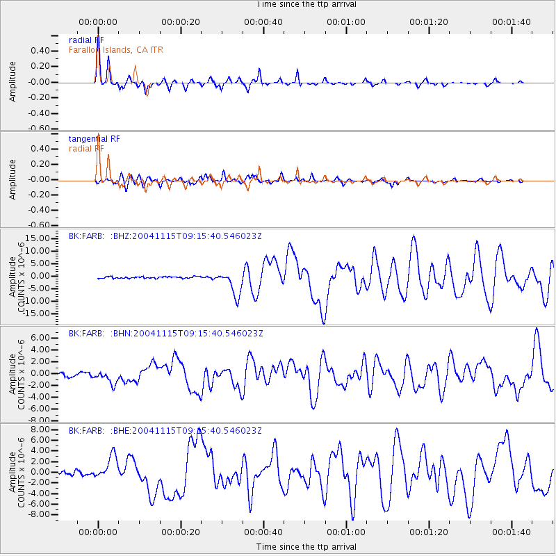
Earthquake location: Near West Coast Of Colombia
Earthquake latitude/longitude: 4.7/-77.5
Earthquake time(UTC): 2004/11/15 (320) 09:06:56 GMT
Earthquake Depth: 15 km
Earthquake Magnitude: 6.6 MB, 7.1 MS, 7.2 MW, 7.1 MW
Earthquake Catalog/Contributor: WHDF/NEIC
Network: BK Berkeley Digital Seismograph Network
Station: FARB Farallon Islands, CA
Lat/Lon: 37.70 N/123.00 W
Elevation: -18.5 m
Distance: 52.9 deg
Az: 314.796 deg
Baz: 116.921 deg
Ray Param: 0.066472694
Estimated Moho Depth: 16.75 km
Estimated Crust Vp/Vs: 1.89
Assumed Crust Vp: 6.183 km/s
Estimated Crust Vs: 3.271 km/s
Estimated Crust Poisson's Ratio: 0.31
Radial Match: 97.4474 %
Radial Bump: 215
Transverse Match: 85.19235 %
Transverse Bump: 400
SOD ConfigId: 2459
Insert Time: 2010-03-05 19:17:18.193 +0000
GWidth: 2.5
Max Bumps: 400
Tol: 0.001

Signal To Noise

ChannelStoNSTALTA
BK:FARB: :BHN:20041115T09:15:40.546023Z3.77601121.1439588E-63.029543E-7
BK:FARB: :BHE:20041115T09:15:40.546023Z6.8177752.270133E-63.3297275E-7
BK:FARB: :BHZ:20041115T09:15:40.546023Z16.7734815.199402E-63.0997754E-7
Arrivals
Ps2.5 SECOND
PpPs7.5 SECOND
PsPs/PpSs10.0 SECOND