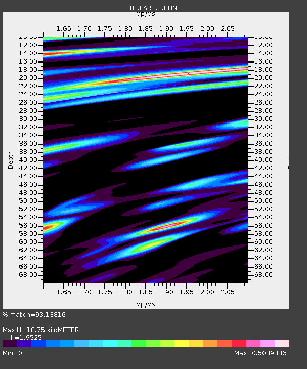
FARB Farallon Islands, CA - Earthquake Result Viewer
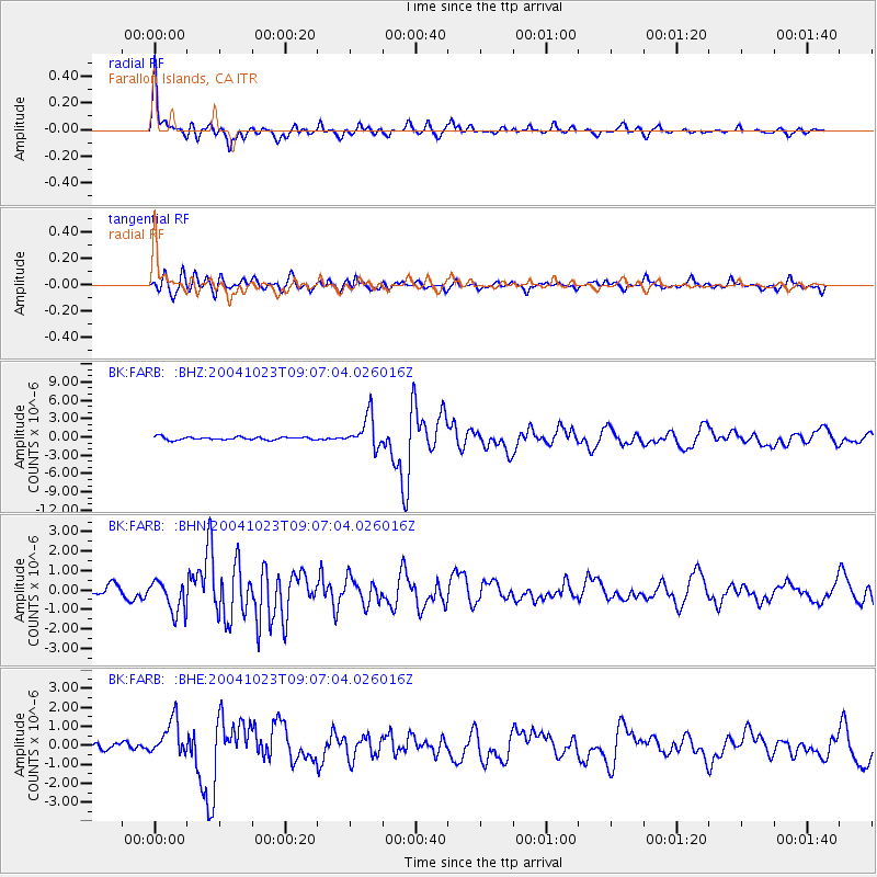
Earthquake location: Near West Coast Of Honshu, Japan
Earthquake latitude/longitude: 37.2/138.8
Earthquake time(UTC): 2004/10/23 (297) 08:56:00 GMT
Earthquake Depth: 16 km
Earthquake Magnitude: 6.4 MB, 6.3 MS, 6.6 MW, 6.4 MW
Earthquake Catalog/Contributor: WHDF/NEIC
Network: BK Berkeley Digital Seismograph Network
Station: FARB Farallon Islands, CA
Lat/Lon: 37.70 N/123.00 W
Elevation: -18.5 m
Distance: 74.0 deg
Az: 54.773 deg
Baz: 304.714 deg
Ray Param: 0.052642103
Estimated Moho Depth: 18.75 km
Estimated Crust Vp/Vs: 1.95
Assumed Crust Vp: 6.183 km/s
Estimated Crust Vs: 3.167 km/s
Estimated Crust Poisson's Ratio: 0.32
Radial Match: 93.13816 %
Radial Bump: 400
Transverse Match: 77.1229 %
Transverse Bump: 400
SOD ConfigId: 2459
Insert Time: 2010-03-05 19:17:20.003 +0000
GWidth: 2.5
Max Bumps: 400
Tol: 0.001

Signal To Noise

ChannelStoNSTALTA
BK:FARB: :BHN:20041023T09:07:04.026016Z2.96962798.184114E-72.7559392E-7
BK:FARB: :BHE:20041023T09:07:04.026016Z4.411439.4536404E-72.1429877E-7
BK:FARB: :BHZ:20041023T09:07:04.026016Z10.6147022.6065375E-62.4555916E-7
Arrivals
Ps3.0 SECOND
PpPs8.7 SECOND
PsPs/PpSs12 SECOND