You are here: Home > Network List > BK - Berkeley Digital Seismograph Network Stations List
> Station FARB Farallon Islands, CA > Earthquake Result Viewer
FARB Farallon Islands, CA - Earthquake Result Viewer
| Earthquake location: |
Near Coast Of Nicaragua |
| Earthquake latitude/longitude: |
11.4/-86.7 |
| Earthquake time(UTC): |
2004/10/09 (283) 21:26:53 GMT |
| Earthquake Depth: |
35 km |
| Earthquake Magnitude: |
6.0 MB, 7.0 MS, 6.9 MW, 6.8 MW |
| Earthquake Catalog/Contributor: |
WHDF/NEIC |
|
| Network: |
BK Berkeley Digital Seismograph Network |
| Station: |
FARB Farallon Islands, CA |
| Lat/Lon: |
37.70 N/123.00 W |
| Elevation: |
-18.5 m |
|
| Distance: |
41.7 deg |
| Az: |
315.078 deg |
| Baz: |
119.214 deg |
| Ray Param: |
0.07353368 |
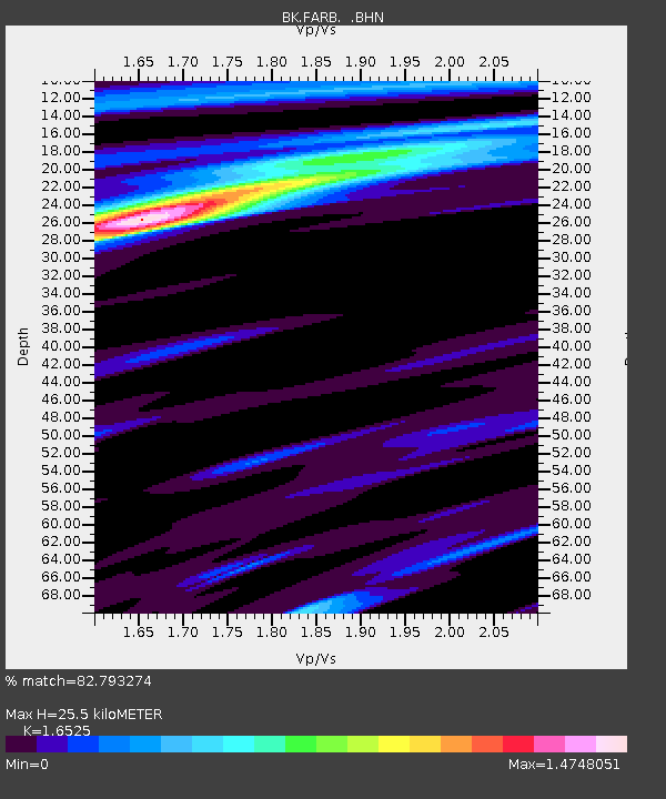
| Estimated Moho Depth: |
25.5 km |
| Estimated Crust Vp/Vs: |
1.65 |
| Assumed Crust Vp: |
6.183 km/s |
| Estimated Crust Vs: |
3.741 km/s |
| Estimated Crust Poisson's Ratio: |
0.21 |
|
| Radial Match: |
82.793274 % |
| Radial Bump: |
314 |
| Transverse Match: |
82.53077 % |
| Transverse Bump: |
360 |
| SOD ConfigId: |
2459 |
| Insert Time: |
2010-03-05 19:17:21.607 +0000 |
| GWidth: |
2.5 |
| Max Bumps: |
400 |
| Tol: |
0.001 |
|
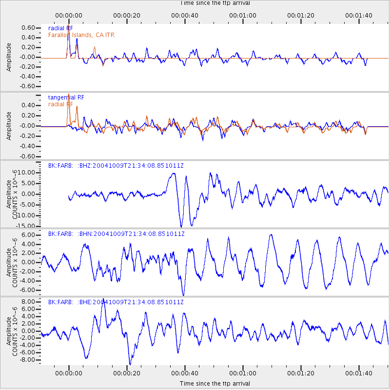
Signal To Noise
| Channel | StoN | STA | LTA |
| BK:FARB: :BHN:20041009T21:34:08.851011Z | 1.6615134 | 1.4094252E-6 | 8.482779E-7 |
| BK:FARB: :BHE:20041009T21:34:08.851011Z | 1.9079555 | 1.6988569E-6 | 8.904069E-7 |
| BK:FARB: :BHZ:20041009T21:34:08.851011Z | 2.7088642 | 2.9517817E-6 | 1.089675E-6 |
| Arrivals |
| Ps | 2.9 SECOND |
| PpPs | 10 SECOND |
| PsPs/PpSs | 13 SECOND |


