You are here: Home > Network List > YT07 - POLENET Stations List
> Station FALL FALL > Earthquake Result Viewer
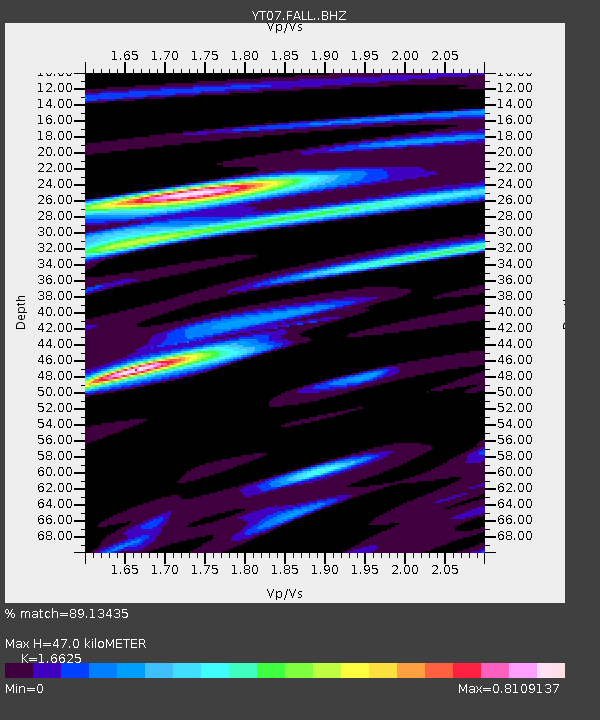
FALL FALL - Earthquake Result Viewer
| Earthquake location: |
New Ireland Region, P.N.G. |
| Earthquake latitude/longitude: |
-4.7/153.2 |
| Earthquake time(UTC): |
2016/10/28 (302) 05:26:57 GMT |
| Earthquake Depth: |
61 km |
| Earthquake Magnitude: |
5.7 MB |
| Earthquake Catalog/Contributor: |
NEIC PDE/NEIC COMCAT |
|
| Network: |
YT POLENET |
| Station: |
FALL FALL |
| Lat/Lon: |
85.31 S/143.63 W |
| Elevation: |
291 m |
|
| Distance: |
83.2 deg |
| Az: |
175.753 deg |
| Baz: |
296.357 deg |
| Ray Param: |
0.046240523 |
| Estimated Moho Depth: |
47.0 km |
| Estimated Crust Vp/Vs: |
1.66 |
| Assumed Crust Vp: |
6.371 km/s |
| Estimated Crust Vs: |
3.832 km/s |
| Estimated Crust Poisson's Ratio: |
0.22 |
|
| Radial Match: |
89.13435 % |
| Radial Bump: |
393 |
| Transverse Match: |
79.87872 % |
| Transverse Bump: |
400 |
| SOD ConfigId: |
11737051 |
| Insert Time: |
2019-04-25 23:13:16.837 +0000 |
| GWidth: |
2.5 |
| Max Bumps: |
400 |
| Tol: |
0.001 |
|

Signal To Noise
| Channel | StoN | STA | LTA |
| YT:FALL: :BHZ:20161028T05:38:46.474983Z | 5.9088025 | 6.609931E-7 | 1.1186583E-7 |
| YT:FALL: :BHN:20161028T05:38:46.474983Z | 3.33287 | 1.3425412E-7 | 4.0281837E-8 |
| YT:FALL: :BHE:20161028T05:38:46.474983Z | 4.536832 | 2.5999924E-7 | 5.7308547E-8 |
| Arrivals |
| Ps | 5.0 SECOND |
| PpPs | 19 SECOND |
| PsPs/PpSs | 24 SECOND |


