You are here: Home > Network List > AG - Arkansas Seismic Network Stations List
> Station U40A Yellville, AR > Earthquake Result Viewer
U40A Yellville, AR - Earthquake Result Viewer
*The percent match for this event was below the threshold and hence no stack was calculated.
| Earthquake location: |
Tyrrhenian Sea |
| Earthquake latitude/longitude: |
39.3/13.5 |
| Earthquake time(UTC): |
2016/10/28 (302) 20:02:48 GMT |
| Earthquake Depth: |
448 km |
| Earthquake Magnitude: |
5.8 MWW, 5.8 MWB |
| Earthquake Catalog/Contributor: |
NEIC PDE/NEIC COMCAT |
|
| Network: |
AG Arkansas Seismic Network |
| Station: |
U40A Yellville, AR |
| Lat/Lon: |
36.36 N/92.85 W |
| Elevation: |
374 m |
|
| Distance: |
78.7 deg |
| Az: |
307.841 deg |
| Baz: |
49.37 deg |
| Ray Param: |
$rayparam |
*The percent match for this event was below the threshold and hence was not used in the summary stack. |
|
| Radial Match: |
68.55486 % |
| Radial Bump: |
400 |
| Transverse Match: |
47.702698 % |
| Transverse Bump: |
368 |
| SOD ConfigId: |
11737051 |
| Insert Time: |
2019-04-25 23:14:39.149 +0000 |
| GWidth: |
2.5 |
| Max Bumps: |
400 |
| Tol: |
0.001 |
|
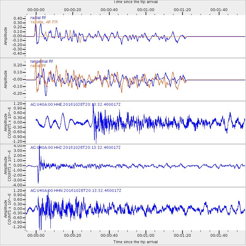
Signal To Noise
| Channel | StoN | STA | LTA |
| AG:U40A:00:HHZ:20161028T20:13:32.460017Z | 6.6610804 | 1.1980802E-6 | 1.7986274E-7 |
| AG:U40A:00:HHN:20161028T20:13:32.460017Z | 2.5982714 | 4.116012E-7 | 1.5841348E-7 |
| AG:U40A:00:HHE:20161028T20:13:32.460017Z | 1.9637508 | 4.5125626E-7 | 2.2979303E-7 |
| Arrivals |
| Ps | |
| PpPs | |
| PsPs/PpSs | |


