You are here: Home > Network List > CB - China National Seismic Network Stations List
> Station GZH Guangzhou,Guangdong Province > Earthquake Result Viewer
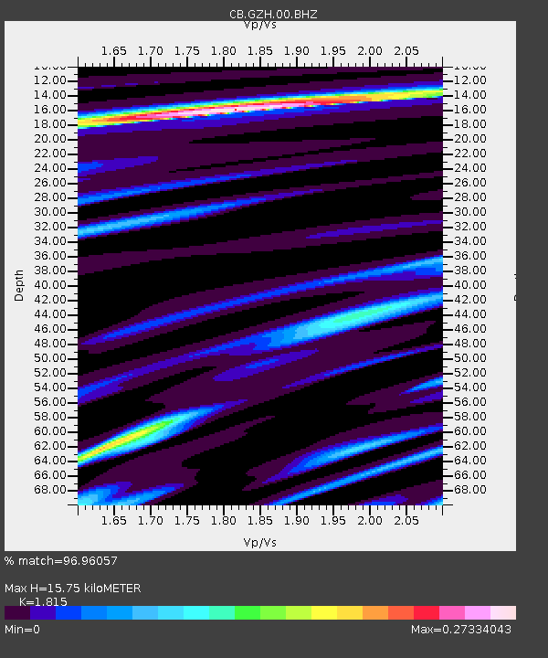
GZH Guangzhou,Guangdong Province - Earthquake Result Viewer
| Earthquake location: |
Tyrrhenian Sea |
| Earthquake latitude/longitude: |
39.3/13.5 |
| Earthquake time(UTC): |
2016/10/28 (302) 20:02:48 GMT |
| Earthquake Depth: |
448 km |
| Earthquake Magnitude: |
5.8 MWW, 5.8 MWB |
| Earthquake Catalog/Contributor: |
NEIC PDE/NEIC COMCAT |
|
| Network: |
CB China National Seismic Network |
| Station: |
GZH Guangzhou,Guangdong Province |
| Lat/Lon: |
23.65 N/113.65 E |
| Elevation: |
65 m |
|
| Distance: |
82.7 deg |
| Az: |
65.515 deg |
| Baz: |
309.653 deg |
| Ray Param: |
0.04544769 |
| Estimated Moho Depth: |
15.75 km |
| Estimated Crust Vp/Vs: |
1.82 |
| Assumed Crust Vp: |
6.276 km/s |
| Estimated Crust Vs: |
3.458 km/s |
| Estimated Crust Poisson's Ratio: |
0.28 |
|
| Radial Match: |
96.96057 % |
| Radial Bump: |
224 |
| Transverse Match: |
14.785109 % |
| Transverse Bump: |
386 |
| SOD ConfigId: |
11737051 |
| Insert Time: |
2019-04-25 23:15:42.938 +0000 |
| GWidth: |
2.5 |
| Max Bumps: |
400 |
| Tol: |
0.001 |
|

Signal To Noise
| Channel | StoN | STA | LTA |
| CB:GZH:00:BHZ:20161028T20:13:53.249995Z | 0.9851814 | 1.9365366E-6 | 1.965665E-6 |
| CB:GZH:00:BHN:20161028T20:13:53.249995Z | 1.2740937 | 4.774928E-7 | 3.747705E-7 |
| CB:GZH:00:BHE:20161028T20:13:53.249995Z | 0.9211799 | 6.9975624E-7 | 7.596304E-7 |
| Arrivals |
| Ps | 2.1 SECOND |
| PpPs | 6.9 SECOND |
| PsPs/PpSs | 9.0 SECOND |


