You are here: Home > Network List > GS - US Geological Survey Networks Stations List
> Station DEC08 Decatur Surface Seismic Site, Decatur, IL, USA > Earthquake Result Viewer
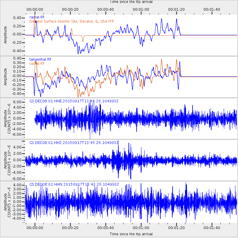
DEC08 Decatur Surface Seismic Site, Decatur, IL, USA - Earthquake Result Viewer
*The percent match for this event was below the threshold and hence no stack was calculated.
| Earthquake location: |
Off Coast Of Central Chile |
| Earthquake latitude/longitude: |
-32.1/-72.4 |
| Earthquake time(UTC): |
2015/09/17 (260) 13:32:26 GMT |
| Earthquake Depth: |
10 km |
| Earthquake Magnitude: |
5.9 MWW, 5.9 MWB, 6.0 MWC |
| Earthquake Catalog/Contributor: |
NEIC PDE/NEIC COMCAT |
|
| Network: |
GS US Geological Survey Networks |
| Station: |
DEC08 Decatur Surface Seismic Site, Decatur, IL, USA |
| Lat/Lon: |
39.86 N/88.92 W |
| Elevation: |
210 m |
|
| Distance: |
73.3 deg |
| Az: |
346.767 deg |
| Baz: |
165.387 deg |
| Ray Param: |
$rayparam |
*The percent match for this event was below the threshold and hence was not used in the summary stack. |
|
| Radial Match: |
54.56083 % |
| Radial Bump: |
400 |
| Transverse Match: |
55.136303 % |
| Transverse Bump: |
400 |
| SOD ConfigId: |
1156111 |
| Insert Time: |
2015-10-24 16:03:11.483 +0000 |
| GWidth: |
2.5 |
| Max Bumps: |
400 |
| Tol: |
0.001 |
|
Signal To Noise
| Channel | StoN | STA | LTA |
| GS:DEC08:01:HHZ:20150917T13:43:26.104993Z | 0.9677886 | 7.5135165E-7 | 7.763593E-7 |
| GS:DEC08:01:HHN:20150917T13:43:26.104993Z | 1.2091454 | 1.6141627E-6 | 1.3349616E-6 |
| GS:DEC08:01:HHE:20150917T13:43:26.104993Z | 1.719441 | 3.1317368E-6 | 1.8213691E-6 |
| Arrivals |
| Ps | |
| PpPs | |
| PsPs/PpSs | |


