You are here: Home > Network List > PF - Volcanologic Network of Piton de Fournaise-OVPF Stations List
> Station BON Bory Nord > Earthquake Result Viewer
BON Bory Nord - Earthquake Result Viewer
*The percent match for this event was below the threshold and hence no stack was calculated.
| Earthquake location: |
Tyrrhenian Sea |
| Earthquake latitude/longitude: |
39.3/13.5 |
| Earthquake time(UTC): |
2016/10/28 (302) 20:02:48 GMT |
| Earthquake Depth: |
448 km |
| Earthquake Magnitude: |
5.8 MWW, 5.8 MWB |
| Earthquake Catalog/Contributor: |
NEIC PDE/NEIC COMCAT |
|
| Network: |
PF Volcanologic Network of Piton de Fournaise-OVPF |
| Station: |
BON Bory Nord |
| Lat/Lon: |
21.24 S/55.71 E |
| Elevation: |
2552 m |
|
| Distance: |
72.0 deg |
| Az: |
138.809 deg |
| Baz: |
326.794 deg |
| Ray Param: |
$rayparam |
*The percent match for this event was below the threshold and hence was not used in the summary stack. |
|
| Radial Match: |
47.203312 % |
| Radial Bump: |
400 |
| Transverse Match: |
45.04141 % |
| Transverse Bump: |
400 |
| SOD ConfigId: |
11737051 |
| Insert Time: |
2019-04-25 23:22:17.165 +0000 |
| GWidth: |
2.5 |
| Max Bumps: |
400 |
| Tol: |
0.001 |
|
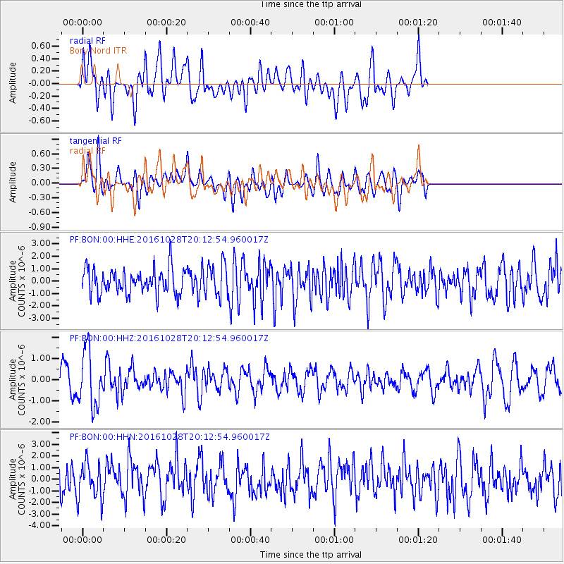
Signal To Noise
| Channel | StoN | STA | LTA |
| PF:BON:00:HHZ:20161028T20:12:54.960017Z | 2.2170405 | 1.3196527E-6 | 5.952317E-7 |
| PF:BON:00:HHN:20161028T20:12:54.960017Z | 1.0490881 | 1.5211915E-6 | 1.450013E-6 |
| PF:BON:00:HHE:20161028T20:12:54.960017Z | 1.3047466 | 1.2945172E-6 | 9.921598E-7 |
| Arrivals |
| Ps | |
| PpPs | |
| PsPs/PpSs | |


