You are here: Home > Network List > TA - USArray Transportable Network (new EarthScope stations) Stations List
> Station G23K Bananza Creek, AK, USA > Earthquake Result Viewer
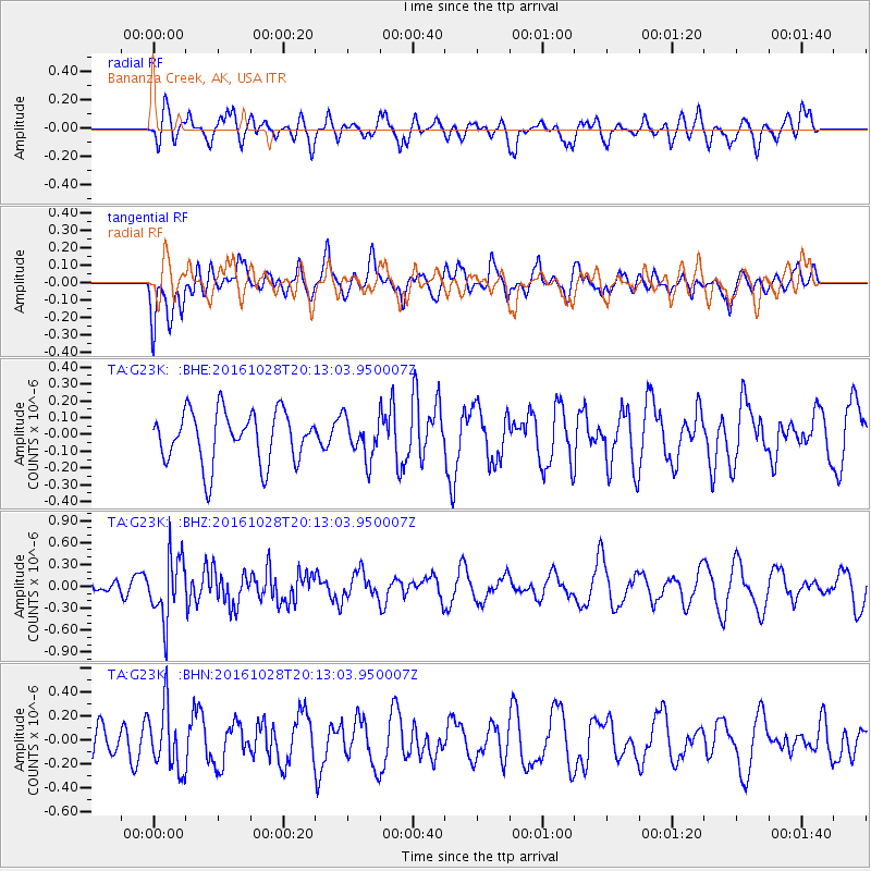
G23K Bananza Creek, AK, USA - Earthquake Result Viewer
*The percent match for this event was below the threshold and hence no stack was calculated.
| Earthquake location: |
Tyrrhenian Sea |
| Earthquake latitude/longitude: |
39.3/13.5 |
| Earthquake time(UTC): |
2016/10/28 (302) 20:02:48 GMT |
| Earthquake Depth: |
448 km |
| Earthquake Magnitude: |
5.8 MWW, 5.8 MWB |
| Earthquake Catalog/Contributor: |
NEIC PDE/NEIC COMCAT |
|
| Network: |
TA USArray Transportable Network (new EarthScope stations) |
| Station: |
G23K Bananza Creek, AK, USA |
| Lat/Lon: |
66.71 N/150.02 W |
| Elevation: |
746 m |
|
| Distance: |
73.6 deg |
| Az: |
353.262 deg |
| Baz: |
13.234 deg |
| Ray Param: |
$rayparam |
*The percent match for this event was below the threshold and hence was not used in the summary stack. |
|
| Radial Match: |
58.56108 % |
| Radial Bump: |
400 |
| Transverse Match: |
60.935894 % |
| Transverse Bump: |
400 |
| SOD ConfigId: |
11737051 |
| Insert Time: |
2019-04-25 23:23:23.411 +0000 |
| GWidth: |
2.5 |
| Max Bumps: |
400 |
| Tol: |
0.001 |
|
Signal To Noise
| Channel | StoN | STA | LTA |
| TA:G23K: :BHZ:20161028T20:13:03.950007Z | 2.5900848 | 4.339986E-7 | 1.6756155E-7 |
| TA:G23K: :BHN:20161028T20:13:03.950007Z | 2.1174293 | 2.6460697E-7 | 1.2496614E-7 |
| TA:G23K: :BHE:20161028T20:13:03.950007Z | 0.7791051 | 1.1955245E-7 | 1.5344841E-7 |
| Arrivals |
| Ps | |
| PpPs | |
| PsPs/PpSs | |


