You are here: Home > Network List > TA - USArray Transportable Network (new EarthScope stations) Stations List
> Station T25A Trinidad, CO, USA > Earthquake Result Viewer
T25A Trinidad, CO, USA - Earthquake Result Viewer
*The percent match for this event was below the threshold and hence no stack was calculated.
| Earthquake location: |
Tyrrhenian Sea |
| Earthquake latitude/longitude: |
39.3/13.5 |
| Earthquake time(UTC): |
2016/10/28 (302) 20:02:48 GMT |
| Earthquake Depth: |
448 km |
| Earthquake Magnitude: |
5.8 MWW, 5.8 MWB |
| Earthquake Catalog/Contributor: |
NEIC PDE/NEIC COMCAT |
|
| Network: |
TA USArray Transportable Network (new EarthScope stations) |
| Station: |
T25A Trinidad, CO, USA |
| Lat/Lon: |
37.14 N/104.41 W |
| Elevation: |
2017 m |
|
| Distance: |
84.9 deg |
| Az: |
314.868 deg |
| Baz: |
43.474 deg |
| Ray Param: |
$rayparam |
*The percent match for this event was below the threshold and hence was not used in the summary stack. |
|
| Radial Match: |
54.191147 % |
| Radial Bump: |
378 |
| Transverse Match: |
44.112 % |
| Transverse Bump: |
400 |
| SOD ConfigId: |
11737051 |
| Insert Time: |
2019-04-25 23:24:03.318 +0000 |
| GWidth: |
2.5 |
| Max Bumps: |
400 |
| Tol: |
0.001 |
|
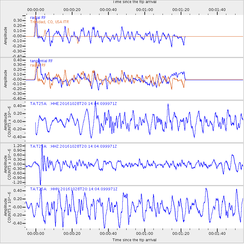
Signal To Noise
| Channel | StoN | STA | LTA |
| TA:T25A: :HHZ:20161028T20:14:04.099971Z | 4.143882 | 5.573874E-7 | 1.3450851E-7 |
| TA:T25A: :HHN:20161028T20:14:04.099971Z | 1.071275 | 2.1683614E-7 | 2.0240941E-7 |
| TA:T25A: :HHE:20161028T20:14:04.099971Z | 2.0826457 | 2.6436646E-7 | 1.269378E-7 |
| Arrivals |
| Ps | |
| PpPs | |
| PsPs/PpSs | |


