You are here: Home > Network List > TJ - Tajikistan National Seismic Network Stations List
> Station GARM Garm, Tajikistan > Earthquake Result Viewer
GARM Garm, Tajikistan - Earthquake Result Viewer
| Earthquake location: |
Tyrrhenian Sea |
| Earthquake latitude/longitude: |
39.3/13.5 |
| Earthquake time(UTC): |
2016/10/28 (302) 20:02:48 GMT |
| Earthquake Depth: |
448 km |
| Earthquake Magnitude: |
5.8 MWW, 5.8 MWB |
| Earthquake Catalog/Contributor: |
NEIC PDE/NEIC COMCAT |
|
| Network: |
TJ Tajikistan National Seismic Network |
| Station: |
GARM Garm, Tajikistan |
| Lat/Lon: |
39.00 N/70.32 E |
| Elevation: |
1305 m |
|
| Distance: |
43.4 deg |
| Az: |
71.599 deg |
| Baz: |
289.145 deg |
| Ray Param: |
0.07052918 |
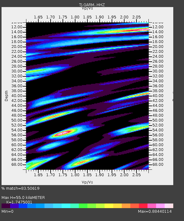
| Estimated Moho Depth: |
55.0 km |
| Estimated Crust Vp/Vs: |
1.75 |
| Assumed Crust Vp: |
6.306 km/s |
| Estimated Crust Vs: |
3.609 km/s |
| Estimated Crust Poisson's Ratio: |
0.26 |
|
| Radial Match: |
83.50619 % |
| Radial Bump: |
400 |
| Transverse Match: |
73.47903 % |
| Transverse Bump: |
389 |
| SOD ConfigId: |
11737051 |
| Insert Time: |
2019-04-25 23:24:12.655 +0000 |
| GWidth: |
2.5 |
| Max Bumps: |
400 |
| Tol: |
0.001 |
|

Signal To Noise
| Channel | StoN | STA | LTA |
| TJ:GARM: :HHZ:20161028T20:09:39.64001Z | 32.27772 | 5.087206E-6 | 1.5760735E-7 |
| TJ:GARM: :HHN:20161028T20:09:39.64001Z | 5.426216 | 1.0245504E-6 | 1.888149E-7 |
| TJ:GARM: :HHE:20161028T20:09:39.64001Z | 22.494326 | 2.6879093E-6 | 1.1949278E-7 |
| Arrivals |
| Ps | 6.9 SECOND |
| PpPs | 23 SECOND |
| PsPs/PpSs | 29 SECOND |


