You are here: Home > Network List > UW - Pacific Northwest Regional Seismic Network Stations List
> Station UMAT Pilot Rock, OR, USA > Earthquake Result Viewer
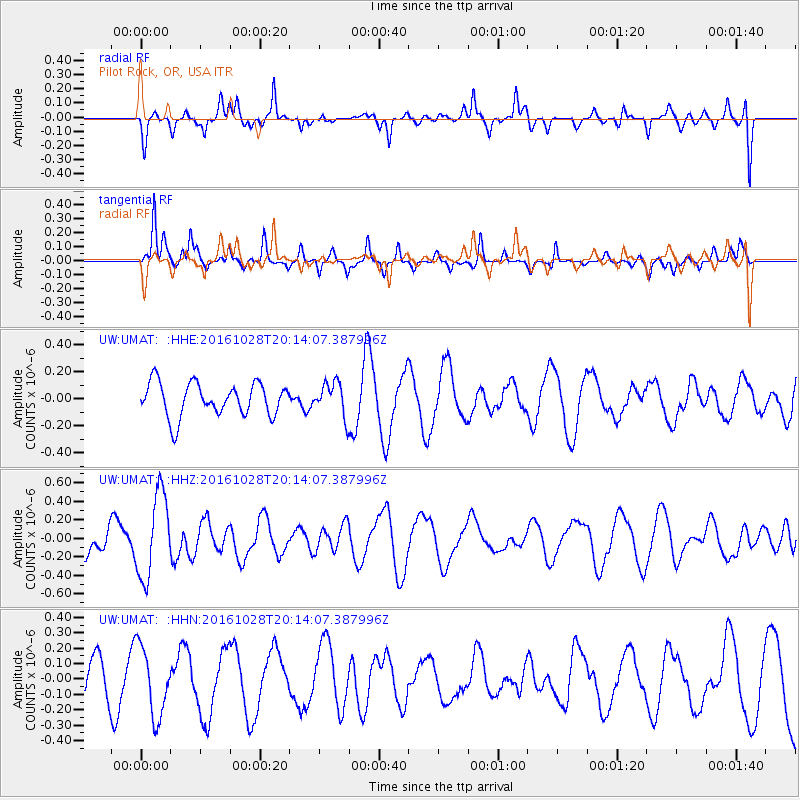
UMAT Pilot Rock, OR, USA - Earthquake Result Viewer
*The percent match for this event was below the threshold and hence no stack was calculated.
| Earthquake location: |
Tyrrhenian Sea |
| Earthquake latitude/longitude: |
39.3/13.5 |
| Earthquake time(UTC): |
2016/10/28 (302) 20:02:48 GMT |
| Earthquake Depth: |
448 km |
| Earthquake Magnitude: |
5.8 MWW, 5.8 MWB |
| Earthquake Catalog/Contributor: |
NEIC PDE/NEIC COMCAT |
|
| Network: |
UW Pacific Northwest Regional Seismic Network |
| Station: |
UMAT Pilot Rock, OR, USA |
| Lat/Lon: |
45.29 N/118.96 W |
| Elevation: |
1318 m |
|
| Distance: |
85.6 deg |
| Az: |
328.531 deg |
| Baz: |
35.009 deg |
| Ray Param: |
$rayparam |
*The percent match for this event was below the threshold and hence was not used in the summary stack. |
|
| Radial Match: |
75.78973 % |
| Radial Bump: |
381 |
| Transverse Match: |
72.406105 % |
| Transverse Bump: |
332 |
| SOD ConfigId: |
11737051 |
| Insert Time: |
2019-04-25 23:24:48.343 +0000 |
| GWidth: |
2.5 |
| Max Bumps: |
400 |
| Tol: |
0.001 |
|
Signal To Noise
| Channel | StoN | STA | LTA |
| UW:UMAT: :HHZ:20161028T20:14:07.387996Z | 2.6270905 | 4.5180414E-7 | 1.7197891E-7 |
| UW:UMAT: :HHN:20161028T20:14:07.387996Z | 1.9771618 | 2.2372687E-7 | 1.1315557E-7 |
| UW:UMAT: :HHE:20161028T20:14:07.387996Z | 1.0159783 | 1.2470538E-7 | 1.2274413E-7 |
| Arrivals |
| Ps | |
| PpPs | |
| PsPs/PpSs | |


