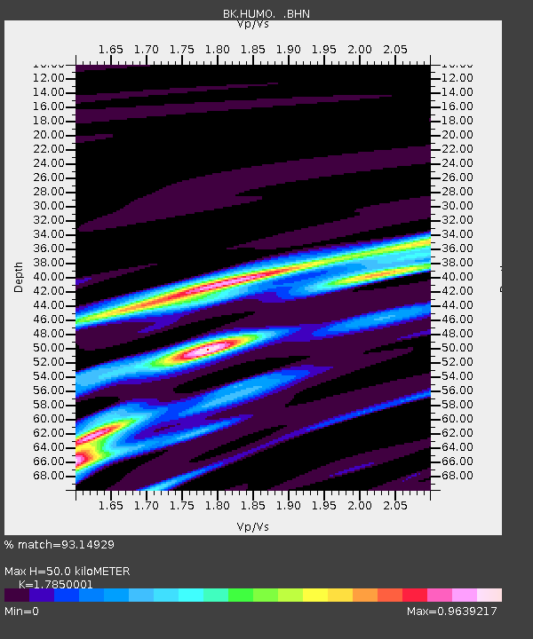
HUMO Hull Mountain, OR - Earthquake Result Viewer
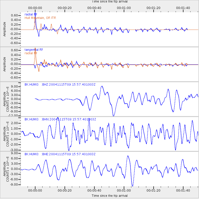
Earthquake location: Near West Coast Of Colombia
Earthquake latitude/longitude: 4.7/-77.5
Earthquake time(UTC): 2004/11/15 (320) 09:06:56 GMT
Earthquake Depth: 15 km
Earthquake Magnitude: 6.6 MB, 7.1 MS, 7.2 MW, 7.1 MW
Earthquake Catalog/Contributor: WHDF/NEIC
Network: BK Berkeley Digital Seismograph Network
Station: HUMO Hull Mountain, OR
Lat/Lon: 42.61 N/122.96 W
Elevation: 555 m
Distance: 55.2 deg
Az: 320.142 deg
Baz: 120.093 deg
Ray Param: 0.064954326
Estimated Moho Depth: 50.0 km
Estimated Crust Vp/Vs: 1.79
Assumed Crust Vp: 6.522 km/s
Estimated Crust Vs: 3.654 km/s
Estimated Crust Poisson's Ratio: 0.27
Radial Match: 93.14929 %
Radial Bump: 316
Transverse Match: 83.57142 %
Transverse Bump: 400
SOD ConfigId: 2459
Insert Time: 2010-03-05 19:20:34.061 +0000
GWidth: 2.5
Max Bumps: 400
Tol: 0.001

Signal To Noise

ChannelStoNSTALTA
BK:HUMO: :BHN:20041115T09:15:57.401003Z2.01176124.824024E-72.397911E-7
BK:HUMO: :BHE:20041115T09:15:57.401003Z12.7040991.5107214E-61.1891606E-7
BK:HUMO: :BHZ:20041115T09:15:57.401003Z7.8581552.3242815E-62.9577953E-7
Arrivals
Ps6.3 SECOND
PpPs20 SECOND
PsPs/PpSs27 SECOND