You are here: Home > Network List > BK - Berkeley Digital Seismograph Network Stations List
> Station HUMO Hull Mountain, OR > Earthquake Result Viewer
HUMO Hull Mountain, OR - Earthquake Result Viewer
| Earthquake location: |
Kermadec Islands Region |
| Earthquake latitude/longitude: |
-31.5/-178.8 |
| Earthquake time(UTC): |
2009/05/16 (136) 00:53:52 GMT |
| Earthquake Depth: |
55 km |
| Earthquake Magnitude: |
6.1 MB, 6.5 MW, 6.3 MW |
| Earthquake Catalog/Contributor: |
WHDF/NEIC |
|
| Network: |
BK Berkeley Digital Seismograph Network |
| Station: |
HUMO Hull Mountain, OR |
| Lat/Lon: |
42.61 N/122.96 W |
| Elevation: |
555 m |
|
| Distance: |
89.8 deg |
| Az: |
37.653 deg |
| Baz: |
224.963 deg |
| Ray Param: |
0.04170872 |
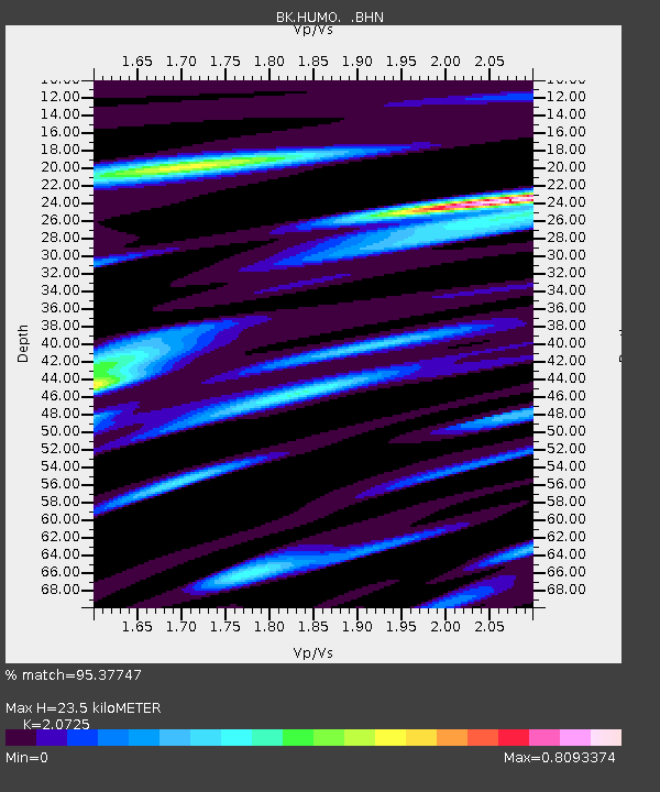
| Estimated Moho Depth: |
23.5 km |
| Estimated Crust Vp/Vs: |
2.07 |
| Assumed Crust Vp: |
6.522 km/s |
| Estimated Crust Vs: |
3.147 km/s |
| Estimated Crust Poisson's Ratio: |
0.35 |
|
| Radial Match: |
95.37747 % |
| Radial Bump: |
400 |
| Transverse Match: |
91.984856 % |
| Transverse Bump: |
400 |
| SOD ConfigId: |
2760 |
| Insert Time: |
2010-03-05 19:21:04.772 +0000 |
| GWidth: |
2.5 |
| Max Bumps: |
400 |
| Tol: |
0.001 |
|
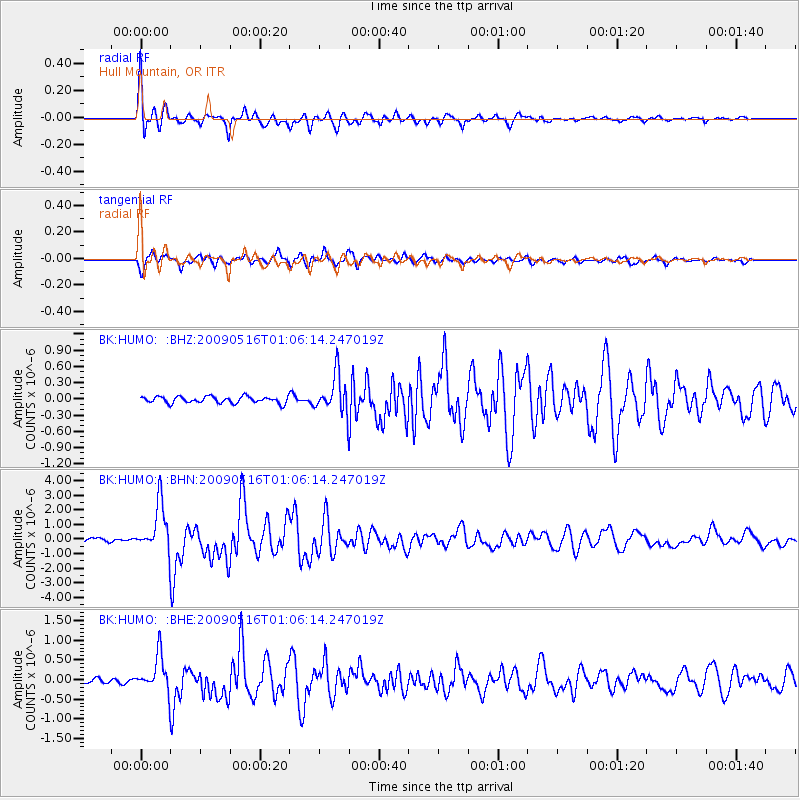
Signal To Noise
| Channel | StoN | STA | LTA |
| BK:HUMO: :BHN:20090516T01:06:14.247019Z | 16.119886 | 1.6477093E-6 | 1.0221593E-7 |
| BK:HUMO: :BHE:20090516T01:06:14.247019Z | 8.614039 | 4.5974042E-7 | 5.337106E-8 |
| BK:HUMO: :BHZ:20090516T01:06:14.247019Z | 5.841723 | 3.5400586E-7 | 6.059956E-8 |
| Arrivals |
| Ps | 3.9 SECOND |
| PpPs | 11 SECOND |
| PsPs/PpSs | 15 SECOND |


