You are here: Home > Network List > BK - Berkeley Digital Seismograph Network Stations List
> Station HUMO Hull Mountain, OR > Earthquake Result Viewer
HUMO Hull Mountain, OR - Earthquake Result Viewer
| Earthquake location: |
Kermadec Islands Region |
| Earthquake latitude/longitude: |
-27.4/-176.3 |
| Earthquake time(UTC): |
2009/02/18 (049) 21:53:45 GMT |
| Earthquake Depth: |
25 km |
| Earthquake Magnitude: |
6.8 MB, 7.2 MS, 6.9 MW, 6.9 MW |
| Earthquake Catalog/Contributor: |
WHDF/NEIC |
|
| Network: |
BK Berkeley Digital Seismograph Network |
| Station: |
HUMO Hull Mountain, OR |
| Lat/Lon: |
42.61 N/122.96 W |
| Elevation: |
555 m |
|
| Distance: |
85.3 deg |
| Az: |
36.478 deg |
| Baz: |
225.709 deg |
| Ray Param: |
0.044859074 |
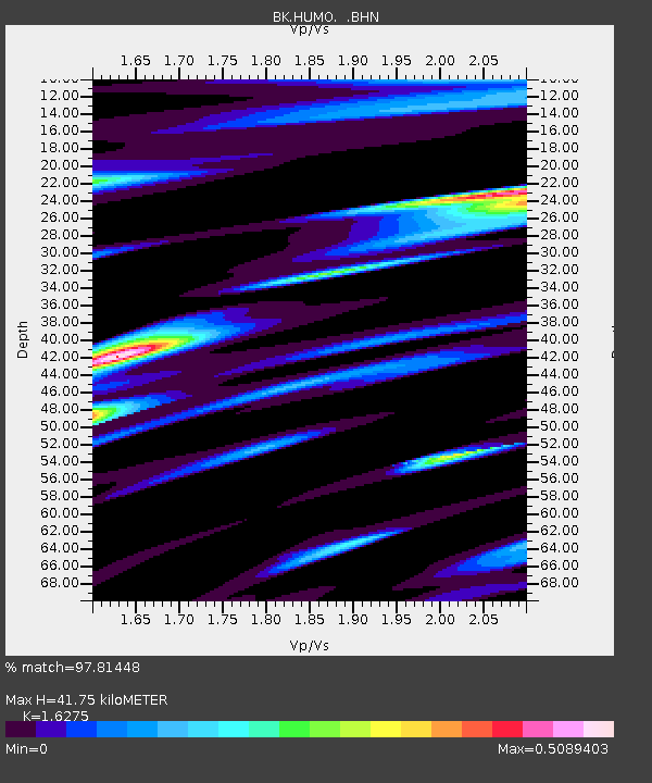
| Estimated Moho Depth: |
41.75 km |
| Estimated Crust Vp/Vs: |
1.63 |
| Assumed Crust Vp: |
6.522 km/s |
| Estimated Crust Vs: |
4.007 km/s |
| Estimated Crust Poisson's Ratio: |
0.20 |
|
| Radial Match: |
97.81448 % |
| Radial Bump: |
400 |
| Transverse Match: |
96.9178 % |
| Transverse Bump: |
395 |
| SOD ConfigId: |
2658 |
| Insert Time: |
2010-03-05 19:21:07.881 +0000 |
| GWidth: |
2.5 |
| Max Bumps: |
400 |
| Tol: |
0.001 |
|
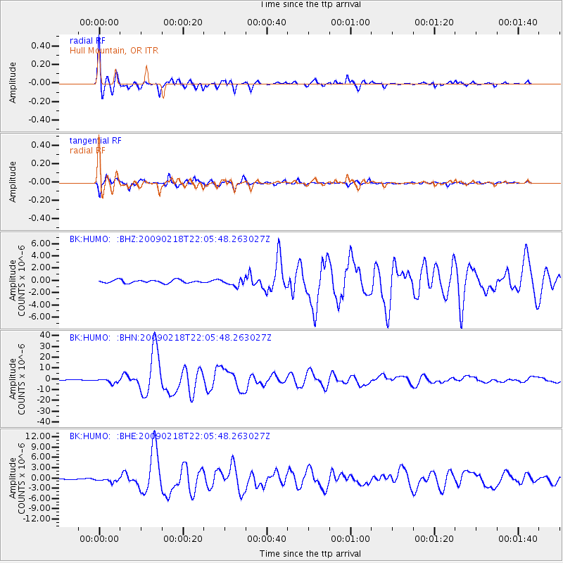
Signal To Noise
| Channel | StoN | STA | LTA |
| BK:HUMO: :BHN:20090218T22:05:48.263027Z | 13.271099 | 2.0991895E-6 | 1.5817751E-7 |
| BK:HUMO: :BHE:20090218T22:05:48.263027Z | 4.134052 | 5.8998955E-7 | 1.427146E-7 |
| BK:HUMO: :BHZ:20090218T22:05:48.263027Z | 2.1762276 | 5.579687E-7 | 2.5639264E-7 |
| Arrivals |
| Ps | 4.1 SECOND |
| PpPs | 16 SECOND |
| PsPs/PpSs | 20 SECOND |


