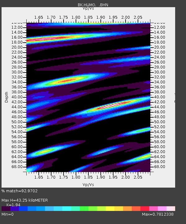
HUMO Hull Mountain, OR - Earthquake Result Viewer
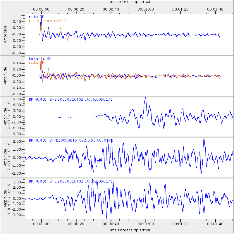
Earthquake location: Near East Coast Of Honshu, Japan
Earthquake latitude/longitude: 38.3/142.0
Earthquake time(UTC): 2005/08/16 (228) 02:46:28 GMT
Earthquake Depth: 36 km
Earthquake Magnitude: 6.5 MB, 6.8 MS, 7.2 MW, 7.1 MW
Earthquake Catalog/Contributor: WHDF/NEIC
Network: BK Berkeley Digital Seismograph Network
Station: HUMO Hull Mountain, OR
Lat/Lon: 42.61 N/122.96 W
Elevation: 555 m
Distance: 68.6 deg
Az: 52.194 deg
Baz: 302.616 deg
Ray Param: 0.056160714
Estimated Moho Depth: 43.25 km
Estimated Crust Vp/Vs: 1.94
Assumed Crust Vp: 6.522 km/s
Estimated Crust Vs: 3.362 km/s
Estimated Crust Poisson's Ratio: 0.32
Radial Match: 92.9702 %
Radial Bump: 400
Transverse Match: 82.554085 %
Transverse Bump: 400
SOD ConfigId: 2475
Insert Time: 2010-03-05 19:22:05.404 +0000
GWidth: 2.5
Max Bumps: 400
Tol: 0.001

Signal To Noise

ChannelStoNSTALTA
BK:HUMO: :BHN:20050816T02:56:56.605017Z1.95287781.6258649E-78.3254825E-8
BK:HUMO: :BHE:20050816T02:56:56.605017Z2.55601262.202899E-78.618498E-8
BK:HUMO: :BHZ:20050816T02:56:56.605017Z7.2025665.811811E-78.0690846E-8
Arrivals
Ps6.5 SECOND
PpPs19 SECOND
PsPs/PpSs25 SECOND