You are here: Home > Network List > AK - Alaska Regional Network Stations List
> Station YAH Yahtse, AK, USA > Earthquake Result Viewer
YAH Yahtse, AK, USA - Earthquake Result Viewer
| Earthquake location: |
Central Italy |
| Earthquake latitude/longitude: |
42.9/13.1 |
| Earthquake time(UTC): |
2016/10/30 (304) 06:40:19 GMT |
| Earthquake Depth: |
10 km |
| Earthquake Magnitude: |
6.6 MWW, 6.6 MWR |
| Earthquake Catalog/Contributor: |
NEIC PDE/NEIC COMCAT |
|
| Network: |
AK Alaska Regional Network |
| Station: |
YAH Yahtse, AK, USA |
| Lat/Lon: |
60.36 N/141.75 W |
| Elevation: |
2125 m |
|
| Distance: |
75.1 deg |
| Az: |
347.368 deg |
| Baz: |
18.876 deg |
| Ray Param: |
0.05189384 |
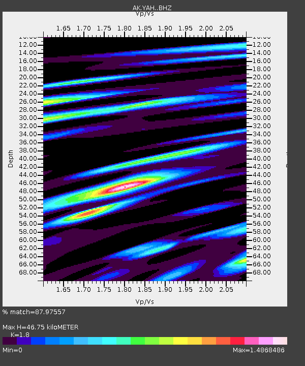
| Estimated Moho Depth: |
46.75 km |
| Estimated Crust Vp/Vs: |
1.80 |
| Assumed Crust Vp: |
6.566 km/s |
| Estimated Crust Vs: |
3.648 km/s |
| Estimated Crust Poisson's Ratio: |
0.28 |
|
| Radial Match: |
87.97557 % |
| Radial Bump: |
400 |
| Transverse Match: |
73.31212 % |
| Transverse Bump: |
400 |
| SOD ConfigId: |
11737051 |
| Insert Time: |
2019-04-25 23:39:54.128 +0000 |
| GWidth: |
2.5 |
| Max Bumps: |
400 |
| Tol: |
0.001 |
|

Signal To Noise
| Channel | StoN | STA | LTA |
| AK:YAH: :BHZ:20161030T06:51:29.908008Z | 4.415976 | 1.2380647E-6 | 2.8036038E-7 |
| AK:YAH: :BHN:20161030T06:51:29.908008Z | 1.9291326 | 6.2977193E-7 | 3.264534E-7 |
| AK:YAH: :BHE:20161030T06:51:29.908008Z | 1.1235508 | 3.9516584E-7 | 3.5171158E-7 |
| Arrivals |
| Ps | 5.9 SECOND |
| PpPs | 19 SECOND |
| PsPs/PpSs | 25 SECOND |


