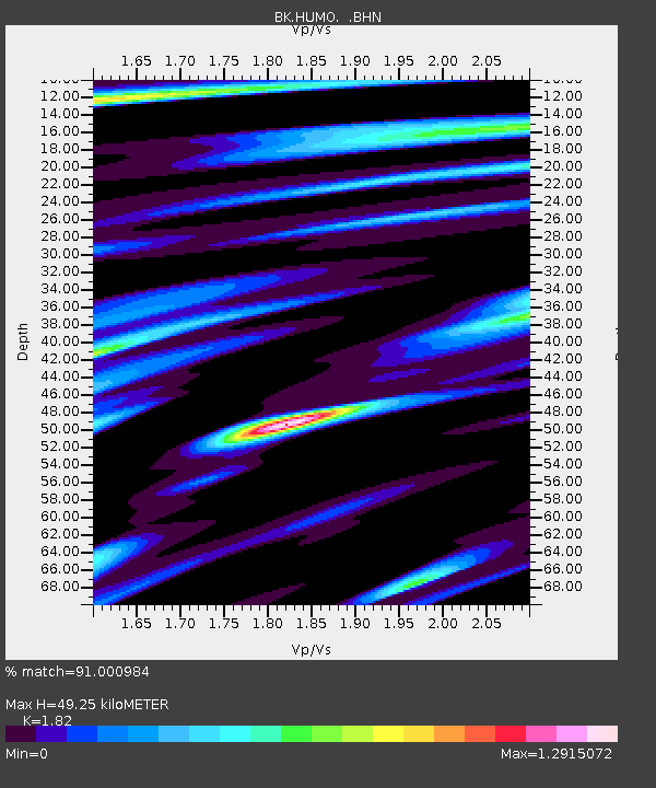
HUMO Hull Mountain, OR - Earthquake Result Viewer

Earthquake location: Andreanof Islands, Aleutian Is.
Earthquake latitude/longitude: 51.9/-179.2
Earthquake time(UTC): 2008/04/16 (107) 05:54:19 GMT
Earthquake Depth: 13 km
Earthquake Magnitude: 6.1 MB, 6.5 MS, 6.6 MW, 6.6 MW
Earthquake Catalog/Contributor: WHDF/NEIC
Network: BK Berkeley Digital Seismograph Network
Station: HUMO Hull Mountain, OR
Lat/Lon: 42.61 N/122.96 W
Elevation: 555 m
Distance: 38.4 deg
Az: 81.114 deg
Baz: 303.944 deg
Ray Param: 0.0755821
Estimated Moho Depth: 49.25 km
Estimated Crust Vp/Vs: 1.82
Assumed Crust Vp: 6.522 km/s
Estimated Crust Vs: 3.583 km/s
Estimated Crust Poisson's Ratio: 0.28
Radial Match: 91.000984 %
Radial Bump: 330
Transverse Match: 79.46253 %
Transverse Bump: 400
SOD ConfigId: 2504
Insert Time: 2010-03-05 19:22:19.450 +0000
GWidth: 2.5
Max Bumps: 400
Tol: 0.001

Signal To Noise

ChannelStoNSTALTA
BK:HUMO: :BHN:20080416T06:01:09.75601Z3.06115826.194577E-72.0236057E-7
BK:HUMO: :BHE:20080416T06:01:09.75601Z1.30102742.4107192E-71.8529349E-7
BK:HUMO: :BHZ:20080416T06:01:09.75601Z1.99350154.3127355E-72.1633971E-7
Arrivals
Ps6.7 SECOND
PpPs20 SECOND
PsPs/PpSs26 SECOND