You are here: Home > Network List > BK - Berkeley Digital Seismograph Network Stations List
> Station HUMO Hull Mountain, OR > Earthquake Result Viewer
HUMO Hull Mountain, OR - Earthquake Result Viewer
| Earthquake location: |
Sea Of Okhotsk |
| Earthquake latitude/longitude: |
53.9/152.9 |
| Earthquake time(UTC): |
2008/07/05 (187) 02:12:04 GMT |
| Earthquake Depth: |
633 km |
| Earthquake Magnitude: |
6.8 MB, 7.7 MW, 7.7 MW |
| Earthquake Catalog/Contributor: |
WHDF/NEIC |
|
| Network: |
BK Berkeley Digital Seismograph Network |
| Station: |
HUMO Hull Mountain, OR |
| Lat/Lon: |
42.61 N/122.96 W |
| Elevation: |
555 m |
|
| Distance: |
54.0 deg |
| Az: |
65.239 deg |
| Baz: |
313.265 deg |
| Ray Param: |
0.06290852 |
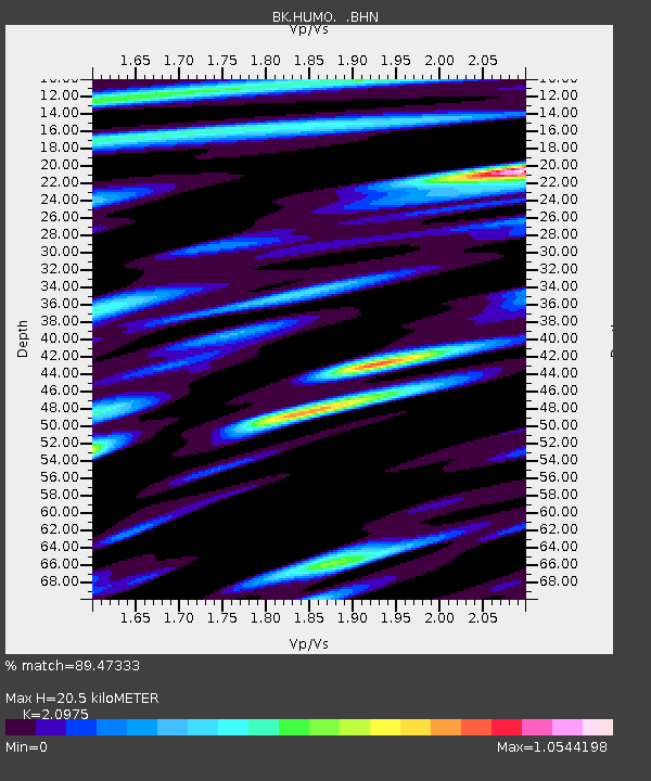
| Estimated Moho Depth: |
20.5 km |
| Estimated Crust Vp/Vs: |
2.10 |
| Assumed Crust Vp: |
6.522 km/s |
| Estimated Crust Vs: |
3.109 km/s |
| Estimated Crust Poisson's Ratio: |
0.35 |
|
| Radial Match: |
89.47333 % |
| Radial Bump: |
400 |
| Transverse Match: |
80.49462 % |
| Transverse Bump: |
400 |
| SOD ConfigId: |
2504 |
| Insert Time: |
2010-03-05 19:22:39.384 +0000 |
| GWidth: |
2.5 |
| Max Bumps: |
400 |
| Tol: |
0.001 |
|

Signal To Noise
| Channel | StoN | STA | LTA |
| BK:HUMO: :BHN:20080705T02:20:00.482014Z | 23.014177 | 2.6905102E-6 | 1.1690664E-7 |
| BK:HUMO: :BHE:20080705T02:20:00.482014Z | 14.439471 | 1.0063956E-6 | 6.9697535E-8 |
| BK:HUMO: :BHZ:20080705T02:20:00.482014Z | 19.452324 | 1.4449585E-6 | 7.4282056E-8 |
| Arrivals |
| Ps | 3.6 SECOND |
| PpPs | 9.3 SECOND |
| PsPs/PpSs | 13 SECOND |


