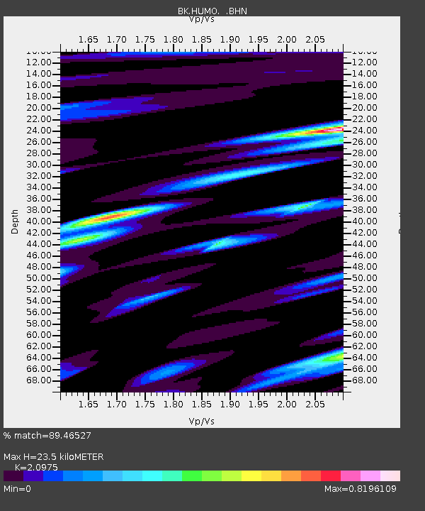
HUMO Hull Mountain, OR - Earthquake Result Viewer

Earthquake location: Southeast Of Loyalty Islands
Earthquake latitude/longitude: -21.1/169.3
Earthquake time(UTC): 2007/09/27 (270) 19:57:44 GMT
Earthquake Depth: 9.0 km
Earthquake Magnitude: 6.2 MB, 6.3 MS, 6.1 MW, 6.1 MW
Earthquake Catalog/Contributor: WHDF/NEIC
Network: BK Berkeley Digital Seismograph Network
Station: HUMO Hull Mountain, OR
Lat/Lon: 42.61 N/122.96 W
Elevation: 555 m
Distance: 88.9 deg
Az: 43.116 deg
Baz: 239.819 deg
Ray Param: 0.042255584
Estimated Moho Depth: 23.5 km
Estimated Crust Vp/Vs: 2.10
Assumed Crust Vp: 6.522 km/s
Estimated Crust Vs: 3.109 km/s
Estimated Crust Poisson's Ratio: 0.35
Radial Match: 89.46527 %
Radial Bump: 400
Transverse Match: 88.766396 %
Transverse Bump: 400
SOD ConfigId: 2564
Insert Time: 2010-03-05 19:23:34.634 +0000
GWidth: 2.5
Max Bumps: 400
Tol: 0.001

Signal To Noise

ChannelStoNSTALTA
BK:HUMO: :BHN:20070927T20:10:06.978027Z1.65032291.7499315E-71.06035706E-7
BK:HUMO: :BHE:20070927T20:10:06.978027Z2.69842932.0769619E-77.696929E-8
BK:HUMO: :BHZ:20070927T20:10:06.978027Z4.24406436.861085E-71.6166307E-7
Arrivals
Ps4.0 SECOND
PpPs11 SECOND
PsPs/PpSs15 SECOND