You are here: Home > Network List > N4 - Central and EAstern US Network Stations List
> Station G40A Rib Lake, WI, USA > Earthquake Result Viewer
G40A Rib Lake, WI, USA - Earthquake Result Viewer
| Earthquake location: |
Central Italy |
| Earthquake latitude/longitude: |
42.9/13.1 |
| Earthquake time(UTC): |
2016/10/30 (304) 06:40:19 GMT |
| Earthquake Depth: |
10 km |
| Earthquake Magnitude: |
6.6 MWW, 6.6 MWR |
| Earthquake Catalog/Contributor: |
NEIC PDE/NEIC COMCAT |
|
| Network: |
N4 Central and EAstern US Network |
| Station: |
G40A Rib Lake, WI, USA |
| Lat/Lon: |
45.27 N/90.20 W |
| Elevation: |
472 m |
|
| Distance: |
68.9 deg |
| Az: |
312.541 deg |
| Baz: |
50.107 deg |
| Ray Param: |
0.056020398 |
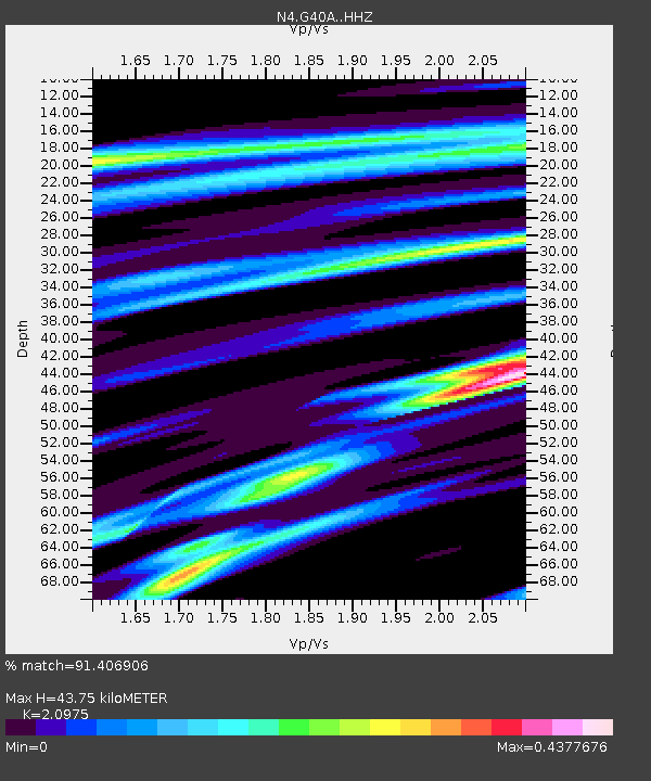
| Estimated Moho Depth: |
43.75 km |
| Estimated Crust Vp/Vs: |
2.10 |
| Assumed Crust Vp: |
6.571 km/s |
| Estimated Crust Vs: |
3.133 km/s |
| Estimated Crust Poisson's Ratio: |
0.35 |
|
| Radial Match: |
91.406906 % |
| Radial Bump: |
203 |
| Transverse Match: |
68.382385 % |
| Transverse Bump: |
400 |
| SOD ConfigId: |
11737051 |
| Insert Time: |
2019-04-25 23:44:51.784 +0000 |
| GWidth: |
2.5 |
| Max Bumps: |
400 |
| Tol: |
0.001 |
|

Signal To Noise
| Channel | StoN | STA | LTA |
| N4:G40A: :HHZ:20161030T06:50:52.669971Z | 7.1943855 | 1.437849E-6 | 1.9985711E-7 |
| N4:G40A: :HHN:20161030T06:50:52.669971Z | 2.4243677 | 4.6828424E-7 | 1.9315726E-7 |
| N4:G40A: :HHE:20161030T06:50:52.669971Z | 1.9664471 | 4.2121331E-7 | 2.1420018E-7 |
| Arrivals |
| Ps | 7.6 SECOND |
| PpPs | 20 SECOND |
| PsPs/PpSs | 27 SECOND |


