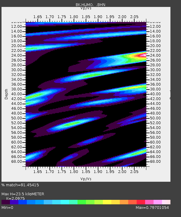
HUMO Hull Mountain, OR - Earthquake Result Viewer
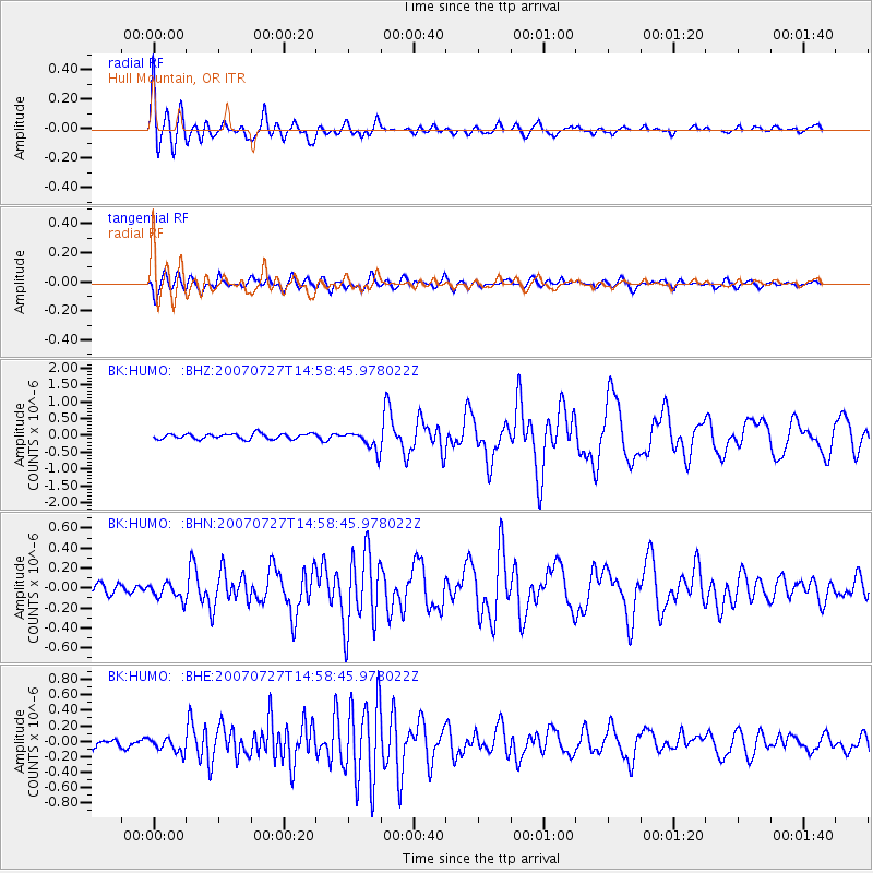
Earthquake location: Southeast Of Loyalty Islands
Earthquake latitude/longitude: -21.5/170.9
Earthquake time(UTC): 2007/07/27 (208) 14:46:26 GMT
Earthquake Depth: 10 km
Earthquake Magnitude: 6.0 MB, 6.0 MS, 6.1 MW, 6.1 MW
Earthquake Catalog/Contributor: WHDF/NEIC
Network: BK Berkeley Digital Seismograph Network
Station: HUMO Hull Mountain, OR
Lat/Lon: 42.61 N/122.96 W
Elevation: 555 m
Distance: 88.1 deg
Az: 42.483 deg
Baz: 238.445 deg
Ray Param: 0.042841878
Estimated Moho Depth: 23.5 km
Estimated Crust Vp/Vs: 2.10
Assumed Crust Vp: 6.522 km/s
Estimated Crust Vs: 3.109 km/s
Estimated Crust Poisson's Ratio: 0.35
Radial Match: 91.45415 %
Radial Bump: 400
Transverse Match: 89.00993 %
Transverse Bump: 400
SOD ConfigId: 2564
Insert Time: 2010-03-05 19:24:02.790 +0000
GWidth: 2.5
Max Bumps: 400
Tol: 0.001

Signal To Noise

ChannelStoNSTALTA
BK:HUMO: :BHN:20070727T14:58:45.978022Z1.28144068.342617E-86.510343E-8
BK:HUMO: :BHE:20070727T14:58:45.978022Z1.74102569.372902E-85.3835524E-8
BK:HUMO: :BHZ:20070727T14:58:45.978022Z3.67088942.902489E-77.9067725E-8
Arrivals
Ps4.0 SECOND
PpPs11 SECOND
PsPs/PpSs15 SECOND