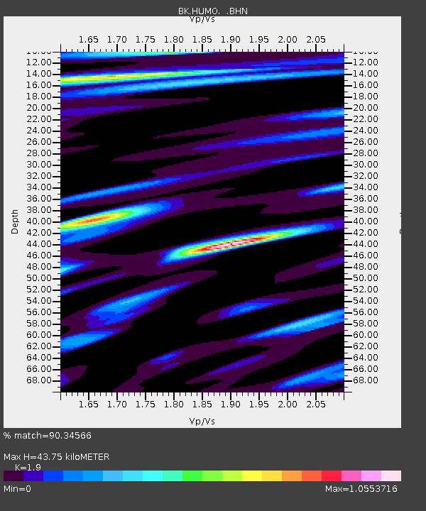
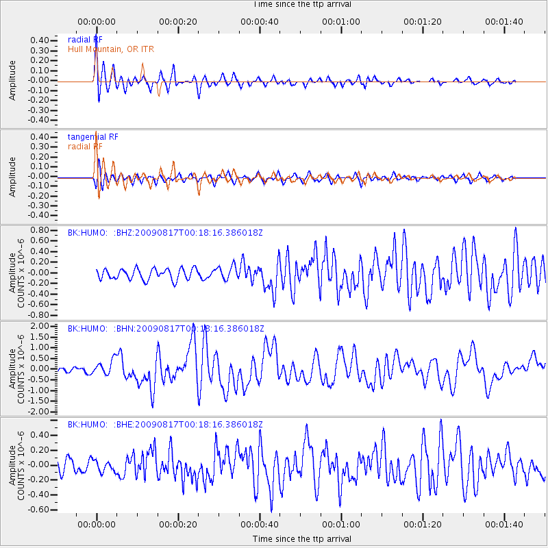
HUMO Hull Mountain, OR - Earthquake Result Viewer

Earthquake location: Southwestern Ryukyu Isl., Japan
Earthquake latitude/longitude: 23.5/123.5
Earthquake time(UTC): 2009/08/17 (229) 00:05:49 GMT
Earthquake Depth: 20 km
Earthquake Magnitude: 6.2 MB, 6.6 MS, 6.7 MW, 6.6 MW
Earthquake Catalog/Contributor: WHDF/NEIC
Network: BK Berkeley Digital Seismograph Network
Station: HUMO Hull Mountain, OR
Lat/Lon: 42.61 N/122.96 W
Elevation: 555 m
Distance: 90.2 deg
Az: 42.595 deg
Baz: 302.69 deg
Ray Param: 0.041689586
Estimated Moho Depth: 43.75 km
Estimated Crust Vp/Vs: 1.90
Assumed Crust Vp: 6.522 km/s
Estimated Crust Vs: 3.432 km/s
Estimated Crust Poisson's Ratio: 0.31
Radial Match: 90.34566 %
Radial Bump: 372
Transverse Match: 78.420616 %
Transverse Bump: 400
SOD ConfigId: 2622
Insert Time: 2010-03-05 19:24:33.124 +0000
GWidth: 2.5
Max Bumps: 400
Tol: 0.001

Signal To Noise

ChannelStoNSTALTA
BK:HUMO: :BHN:20090817T00:18:16.386018Z2.95125913.6331016E-71.2310345E-7
BK:HUMO: :BHE:20090817T00:18:16.386018Z0.69726457.085901E-81.0162429E-7
BK:HUMO: :BHZ:20090817T00:18:16.386018Z1.28015481.2808863E-71.0005714E-7
Arrivals
Ps6.2 SECOND
PpPs19 SECOND
PsPs/PpSs25 SECOND