You are here: Home > Network List > OK - Oklahoma Seismic Network Stations List
> Station DEOK Depew, Oklahoma, USA > Earthquake Result Viewer
DEOK Depew, Oklahoma, USA - Earthquake Result Viewer
| Earthquake location: |
Central Italy |
| Earthquake latitude/longitude: |
42.9/13.1 |
| Earthquake time(UTC): |
2016/10/30 (304) 06:40:19 GMT |
| Earthquake Depth: |
10 km |
| Earthquake Magnitude: |
6.6 MWW, 6.6 MWR |
| Earthquake Catalog/Contributor: |
NEIC PDE/NEIC COMCAT |
|
| Network: |
OK Oklahoma Seismic Network |
| Station: |
DEOK Depew, Oklahoma, USA |
| Lat/Lon: |
35.84 N/96.50 W |
| Elevation: |
291 m |
|
| Distance: |
78.8 deg |
| Az: |
308.701 deg |
| Baz: |
44.937 deg |
| Ray Param: |
0.049417637 |
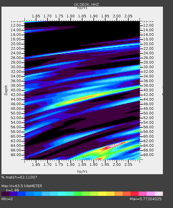
| Estimated Moho Depth: |
63.5 km |
| Estimated Crust Vp/Vs: |
1.99 |
| Assumed Crust Vp: |
6.426 km/s |
| Estimated Crust Vs: |
3.229 km/s |
| Estimated Crust Poisson's Ratio: |
0.33 |
|
| Radial Match: |
82.11007 % |
| Radial Bump: |
400 |
| Transverse Match: |
56.611973 % |
| Transverse Bump: |
400 |
| SOD ConfigId: |
11737051 |
| Insert Time: |
2019-04-25 23:47:21.165 +0000 |
| GWidth: |
2.5 |
| Max Bumps: |
400 |
| Tol: |
0.001 |
|

Signal To Noise
| Channel | StoN | STA | LTA |
| OK:DEOK: :HHZ:20161030T06:51:50.51897Z | 3.2173822 | 1.3660319E-6 | 4.245787E-7 |
| OK:DEOK: :HHN:20161030T06:51:50.51897Z | 1.026478 | 6.613841E-7 | 6.443236E-7 |
| OK:DEOK: :HHE:20161030T06:51:50.51897Z | 0.96172744 | 3.9062314E-7 | 4.0616825E-7 |
| Arrivals |
| Ps | 10 SECOND |
| PpPs | 29 SECOND |
| PsPs/PpSs | 39 SECOND |


