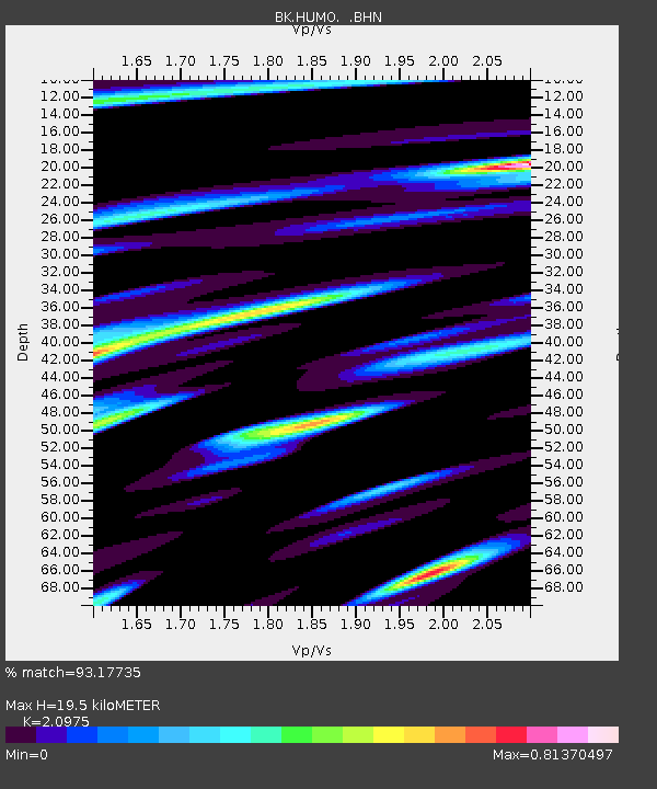
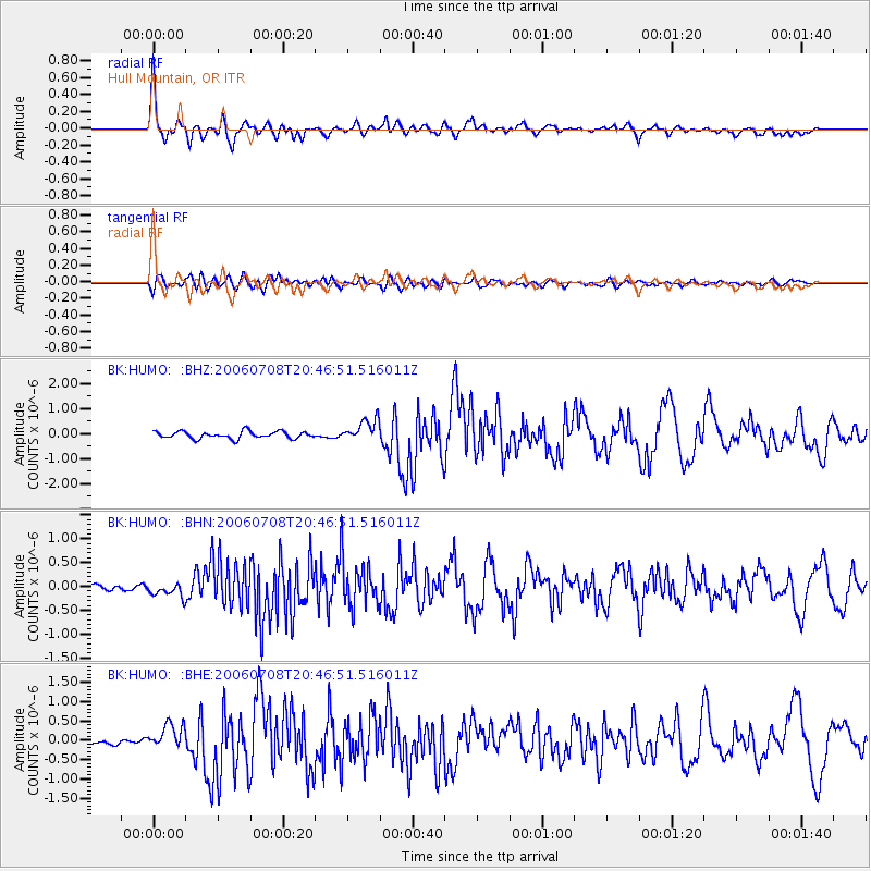
HUMO Hull Mountain, OR - Earthquake Result Viewer

Earthquake location: Andreanof Islands, Aleutian Is.
Earthquake latitude/longitude: 51.2/-179.3
Earthquake time(UTC): 2006/07/08 (189) 20:40:00 GMT
Earthquake Depth: 22 km
Earthquake Magnitude: 6.2 MB, 6.4 MS, 6.6 MW, 6.6 MW
Earthquake Catalog/Contributor: WHDF/NEIC
Network: BK Berkeley Digital Seismograph Network
Station: HUMO Hull Mountain, OR
Lat/Lon: 42.61 N/122.96 W
Elevation: 555 m
Distance: 38.6 deg
Az: 80.192 deg
Baz: 302.913 deg
Ray Param: 0.07544372
Estimated Moho Depth: 19.5 km
Estimated Crust Vp/Vs: 2.10
Assumed Crust Vp: 6.522 km/s
Estimated Crust Vs: 3.109 km/s
Estimated Crust Poisson's Ratio: 0.35
Radial Match: 93.17735 %
Radial Bump: 400
Transverse Match: 82.57624 %
Transverse Bump: 400
SOD ConfigId: 2665
Insert Time: 2010-03-05 19:25:21.227 +0000
GWidth: 2.5
Max Bumps: 400
Tol: 0.001

Signal To Noise

ChannelStoNSTALTA
BK:HUMO: :BHN:20060708T20:46:51.516011Z1.4491391.4482119E-79.9936024E-8
BK:HUMO: :BHE:20060708T20:46:51.516011Z4.7716553.1258293E-76.550829E-8
BK:HUMO: :BHZ:20060708T20:46:51.516011Z3.09772184.4018572E-71.4209982E-7
Arrivals
Ps3.5 SECOND
PpPs8.7 SECOND
PsPs/PpSs12 SECOND