You are here: Home > Network List > TA - USArray Transportable Network (new EarthScope stations) Stations List
> Station F26K Sheenjek River, AK, USA > Earthquake Result Viewer
F26K Sheenjek River, AK, USA - Earthquake Result Viewer
| Earthquake location: |
Central Italy |
| Earthquake latitude/longitude: |
42.9/13.1 |
| Earthquake time(UTC): |
2016/10/30 (304) 06:40:19 GMT |
| Earthquake Depth: |
10 km |
| Earthquake Magnitude: |
6.6 MWW, 6.6 MWR |
| Earthquake Catalog/Contributor: |
NEIC PDE/NEIC COMCAT |
|
| Network: |
TA USArray Transportable Network (new EarthScope stations) |
| Station: |
F26K Sheenjek River, AK, USA |
| Lat/Lon: |
67.69 N/144.15 W |
| Elevation: |
683 m |
|
| Distance: |
68.4 deg |
| Az: |
350.861 deg |
| Baz: |
17.817 deg |
| Ray Param: |
0.05630464 |
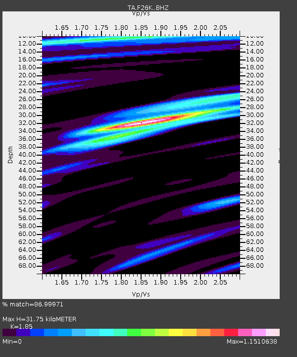
| Estimated Moho Depth: |
31.75 km |
| Estimated Crust Vp/Vs: |
1.85 |
| Assumed Crust Vp: |
6.522 km/s |
| Estimated Crust Vs: |
3.525 km/s |
| Estimated Crust Poisson's Ratio: |
0.29 |
|
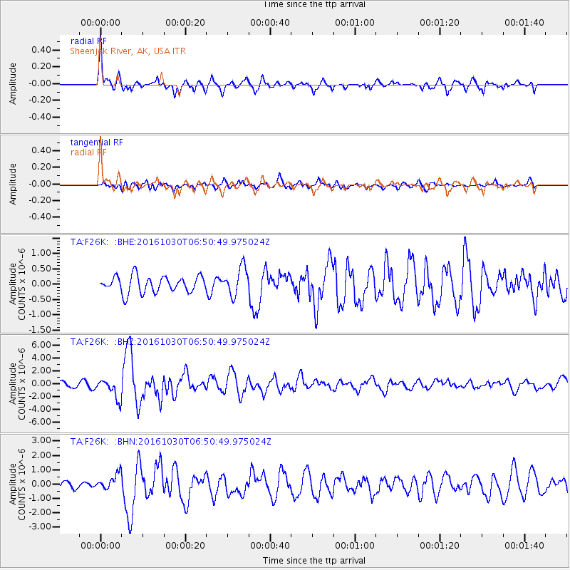
| Radial Match: |
86.99971 % |
| Radial Bump: |
400 |
| Transverse Match: |
71.59253 % |
| Transverse Bump: |
400 |
| SOD ConfigId: |
11737051 |
| Insert Time: |
2019-04-25 23:49:37.060 +0000 |
| GWidth: |
2.5 |
| Max Bumps: |
400 |
| Tol: |
0.001 |
|
Signal To Noise
| Channel | StoN | STA | LTA |
| TA:F26K: :BHZ:20161030T06:50:49.975024Z | 4.8912864 | 1.5612418E-6 | 3.191884E-7 |
| TA:F26K: :BHN:20161030T06:50:49.975024Z | 1.7966468 | 5.747124E-7 | 3.1988054E-7 |
| TA:F26K: :BHE:20161030T06:50:49.975024Z | 1.7520775 | 4.6676882E-7 | 2.664088E-7 |
| Arrivals |
| Ps | 4.3 SECOND |
| PpPs | 13 SECOND |
| PsPs/PpSs | 18 SECOND |


