You are here: Home > Network List > TA - USArray Transportable Network (new EarthScope stations) Stations List
> Station G21K Allakaket, AK, USA > Earthquake Result Viewer
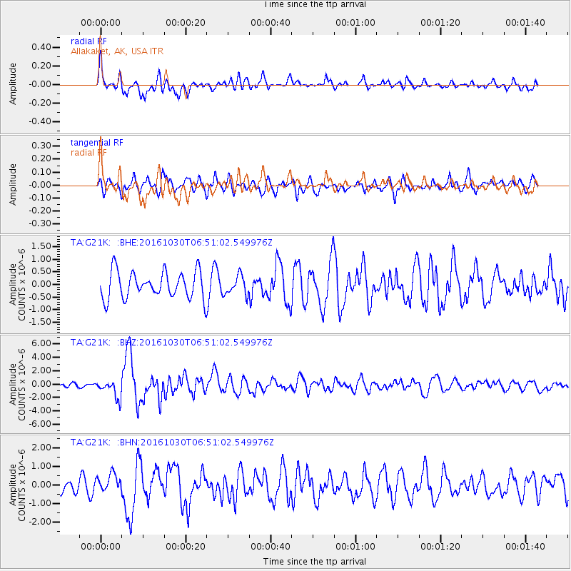
G21K Allakaket, AK, USA - Earthquake Result Viewer
*The percent match for this event was below the threshold and hence no stack was calculated.
| Earthquake location: |
Central Italy |
| Earthquake latitude/longitude: |
42.9/13.1 |
| Earthquake time(UTC): |
2016/10/30 (304) 06:40:19 GMT |
| Earthquake Depth: |
10 km |
| Earthquake Magnitude: |
6.6 MWW, 6.6 MWR |
| Earthquake Catalog/Contributor: |
NEIC PDE/NEIC COMCAT |
|
| Network: |
TA USArray Transportable Network (new EarthScope stations) |
| Station: |
G21K Allakaket, AK, USA |
| Lat/Lon: |
66.52 N/153.51 W |
| Elevation: |
446 m |
|
| Distance: |
70.5 deg |
| Az: |
354.342 deg |
| Baz: |
10.422 deg |
| Ray Param: |
$rayparam |
*The percent match for this event was below the threshold and hence was not used in the summary stack. |
|
| Radial Match: |
71.68034 % |
| Radial Bump: |
400 |
| Transverse Match: |
66.77184 % |
| Transverse Bump: |
400 |
| SOD ConfigId: |
11737051 |
| Insert Time: |
2019-04-25 23:49:37.510 +0000 |
| GWidth: |
2.5 |
| Max Bumps: |
400 |
| Tol: |
0.001 |
|
Signal To Noise
| Channel | StoN | STA | LTA |
| TA:G21K: :BHZ:20161030T06:51:02.549976Z | 3.9315083 | 1.3693708E-6 | 3.4830674E-7 |
| TA:G21K: :BHN:20161030T06:51:02.549976Z | 1.2010499 | 4.9459186E-7 | 4.117996E-7 |
| TA:G21K: :BHE:20161030T06:51:02.549976Z | 0.71911573 | 3.822548E-7 | 5.3156225E-7 |
| Arrivals |
| Ps | |
| PpPs | |
| PsPs/PpSs | |


