You are here: Home > Network List > BK - Berkeley Digital Seismograph Network Stations List
> Station HUMO Hull Mountain, OR > Earthquake Result Viewer
HUMO Hull Mountain, OR - Earthquake Result Viewer
| Earthquake location: |
Fiji Islands Region |
| Earthquake latitude/longitude: |
-19.9/-178.2 |
| Earthquake time(UTC): |
2006/01/02 (002) 22:13:40 GMT |
| Earthquake Depth: |
583 km |
| Earthquake Magnitude: |
6.5 MB, 7.2 MW, 7.1 MW |
| Earthquake Catalog/Contributor: |
WHDF/NEIC |
|
| Network: |
BK Berkeley Digital Seismograph Network |
| Station: |
HUMO Hull Mountain, OR |
| Lat/Lon: |
42.61 N/122.96 W |
| Elevation: |
555 m |
|
| Distance: |
80.3 deg |
| Az: |
37.959 deg |
| Baz: |
231.618 deg |
| Ray Param: |
0.046557482 |
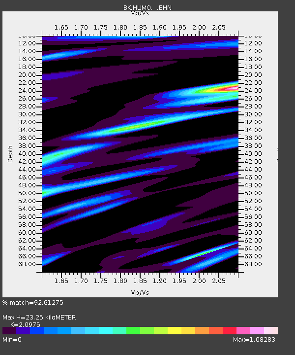
| Estimated Moho Depth: |
23.25 km |
| Estimated Crust Vp/Vs: |
2.10 |
| Assumed Crust Vp: |
6.522 km/s |
| Estimated Crust Vs: |
3.109 km/s |
| Estimated Crust Poisson's Ratio: |
0.35 |
|
| Radial Match: |
92.61275 % |
| Radial Bump: |
400 |
| Transverse Match: |
81.23704 % |
| Transverse Bump: |
400 |
| SOD ConfigId: |
2422 |
| Insert Time: |
2010-03-05 19:25:46.718 +0000 |
| GWidth: |
2.5 |
| Max Bumps: |
400 |
| Tol: |
0.001 |
|
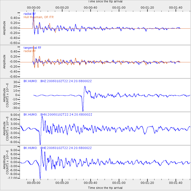
Signal To Noise
| Channel | StoN | STA | LTA |
| BK:HUMO: :BHN:20060102T22:24:20.680002Z | 4.2092614 | 3.410403E-6 | 8.102141E-7 |
| BK:HUMO: :BHE:20060102T22:24:20.680002Z | 4.9969015 | 4.017863E-6 | 8.0407085E-7 |
| BK:HUMO: :BHZ:20060102T22:24:20.680002Z | 16.826078 | 1.1537471E-5 | 6.856899E-7 |
| Arrivals |
| Ps | 4.0 SECOND |
| PpPs | 11 SECOND |
| PsPs/PpSs | 15 SECOND |


