You are here: Home > Network List > UW - Pacific Northwest Regional Seismic Network Stations List
> Station MRBL Marblemount, WA, USA > Earthquake Result Viewer
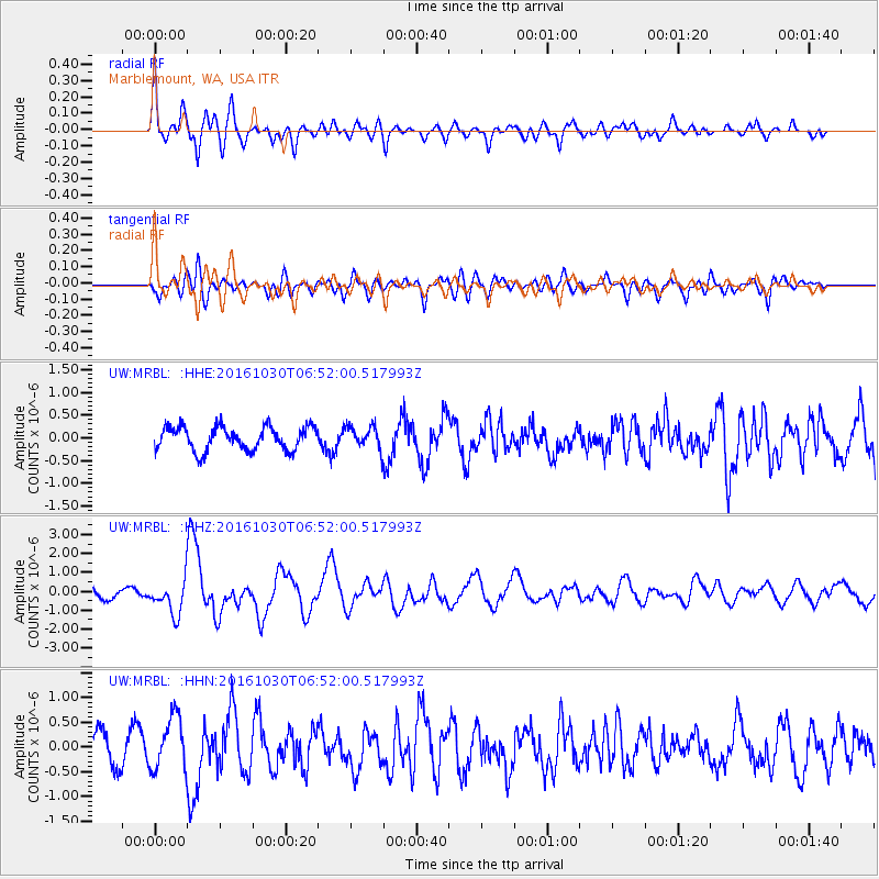
MRBL Marblemount, WA, USA - Earthquake Result Viewer
*The percent match for this event was below the threshold and hence no stack was calculated.
| Earthquake location: |
Central Italy |
| Earthquake latitude/longitude: |
42.9/13.1 |
| Earthquake time(UTC): |
2016/10/30 (304) 06:40:19 GMT |
| Earthquake Depth: |
10 km |
| Earthquake Magnitude: |
6.6 MWW, 6.6 MWR |
| Earthquake Catalog/Contributor: |
NEIC PDE/NEIC COMCAT |
|
| Network: |
UW Pacific Northwest Regional Seismic Network |
| Station: |
MRBL Marblemount, WA, USA |
| Lat/Lon: |
48.52 N/121.48 W |
| Elevation: |
75 m |
|
| Distance: |
80.6 deg |
| Az: |
331.311 deg |
| Baz: |
32.069 deg |
| Ray Param: |
$rayparam |
*The percent match for this event was below the threshold and hence was not used in the summary stack. |
|
| Radial Match: |
70.14752 % |
| Radial Bump: |
400 |
| Transverse Match: |
62.927845 % |
| Transverse Bump: |
400 |
| SOD ConfigId: |
11737051 |
| Insert Time: |
2019-04-25 23:51:49.696 +0000 |
| GWidth: |
2.5 |
| Max Bumps: |
400 |
| Tol: |
0.001 |
|
Signal To Noise
| Channel | StoN | STA | LTA |
| UW:MRBL: :HHZ:20161030T06:52:00.517993Z | 3.6037958 | 8.930201E-7 | 2.4779987E-7 |
| UW:MRBL: :HHN:20161030T06:52:00.517993Z | 2.3470843 | 5.3141514E-7 | 2.2641503E-7 |
| UW:MRBL: :HHE:20161030T06:52:00.517993Z | 0.9741372 | 2.503163E-7 | 2.5696207E-7 |
| Arrivals |
| Ps | |
| PpPs | |
| PsPs/PpSs | |


