You are here: Home > Network List > WI - West Indies IPGP Network Stations List
> Station BIM Morne Bigot, Anses d'Arlets, Martinique > Earthquake Result Viewer
BIM Morne Bigot, Anses d'Arlets, Martinique - Earthquake Result Viewer
| Earthquake location: |
Central Italy |
| Earthquake latitude/longitude: |
42.9/13.1 |
| Earthquake time(UTC): |
2016/10/30 (304) 06:40:19 GMT |
| Earthquake Depth: |
10 km |
| Earthquake Magnitude: |
6.6 MWW, 6.6 MWR |
| Earthquake Catalog/Contributor: |
NEIC PDE/NEIC COMCAT |
|
| Network: |
WI West Indies IPGP Network |
| Station: |
BIM Morne Bigot, Anses d'Arlets, Martinique |
| Lat/Lon: |
14.52 N/61.07 W |
| Elevation: |
391 m |
|
| Distance: |
68.7 deg |
| Az: |
270.245 deg |
| Baz: |
49.401 deg |
| Ray Param: |
0.056133322 |
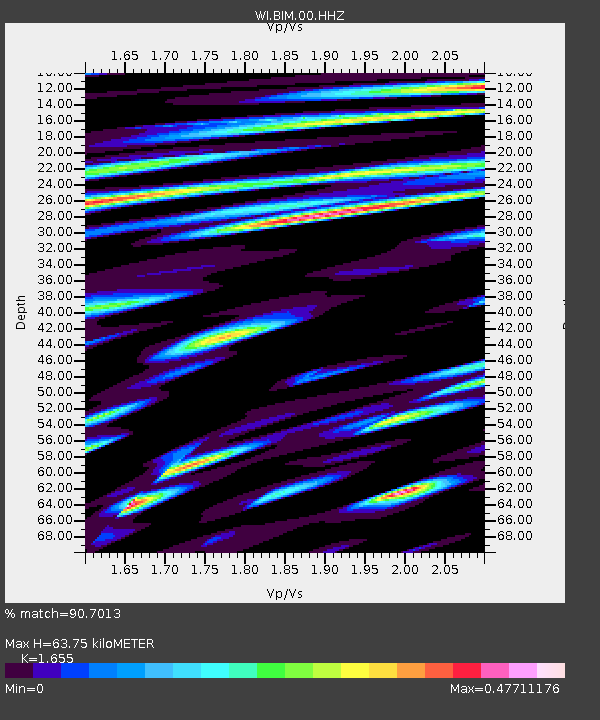
| Estimated Moho Depth: |
63.75 km |
| Estimated Crust Vp/Vs: |
1.65 |
| Assumed Crust Vp: |
5.88 km/s |
| Estimated Crust Vs: |
3.553 km/s |
| Estimated Crust Poisson's Ratio: |
0.21 |
|
| Radial Match: |
90.7013 % |
| Radial Bump: |
400 |
| Transverse Match: |
84.990234 % |
| Transverse Bump: |
400 |
| SOD ConfigId: |
11737051 |
| Insert Time: |
2019-04-25 23:52:04.081 +0000 |
| GWidth: |
2.5 |
| Max Bumps: |
400 |
| Tol: |
0.001 |
|
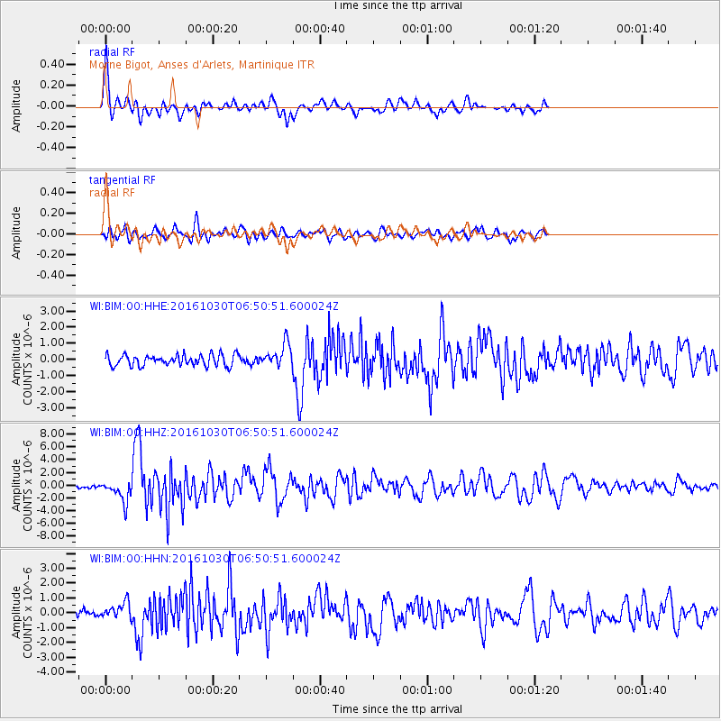
Signal To Noise
| Channel | StoN | STA | LTA |
| WI:BIM:00:HHZ:20161030T06:50:51.600024Z | 8.0543 | 1.6955702E-6 | 2.105174E-7 |
| WI:BIM:00:HHN:20161030T06:50:51.600024Z | 2.1779504 | 5.553293E-7 | 2.5497792E-7 |
| WI:BIM:00:HHE:20161030T06:50:51.600024Z | 2.1579354 | 7.3146487E-7 | 3.3896515E-7 |
| Arrivals |
| Ps | 7.3 SECOND |
| PpPs | 28 SECOND |
| PsPs/PpSs | 35 SECOND |


