You are here: Home > Network List > US - United States National Seismic Network Stations List
> Station MNTX Cornudas Mountains, Texas, USA > Earthquake Result Viewer
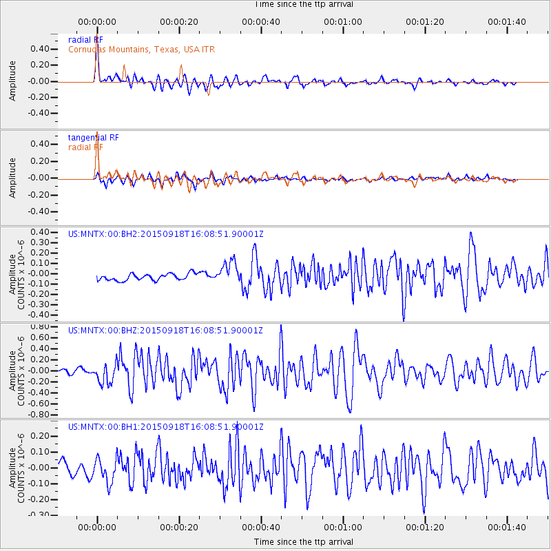
MNTX Cornudas Mountains, Texas, USA - Earthquake Result Viewer
*The percent match for this event was below the threshold and hence no stack was calculated.
| Earthquake location: |
Northern Mid-Atlantic Ridge |
| Earthquake latitude/longitude: |
15.3/-46.0 |
| Earthquake time(UTC): |
2015/09/18 (261) 15:59:42 GMT |
| Earthquake Depth: |
10 km |
| Earthquake Magnitude: |
6.0 MWW, 5.9 MWB, 6.0 MWC |
| Earthquake Catalog/Contributor: |
NEIC PDE/NEIC COMCAT |
|
| Network: |
US United States National Seismic Network |
| Station: |
MNTX Cornudas Mountains, Texas, USA |
| Lat/Lon: |
31.70 N/105.38 W |
| Elevation: |
404 m |
|
| Distance: |
56.2 deg |
| Az: |
298.057 deg |
| Baz: |
92.327 deg |
| Ray Param: |
$rayparam |
*The percent match for this event was below the threshold and hence was not used in the summary stack. |
|
| Radial Match: |
75.809074 % |
| Radial Bump: |
400 |
| Transverse Match: |
60.884018 % |
| Transverse Bump: |
400 |
| SOD ConfigId: |
1156111 |
| Insert Time: |
2015-10-24 22:09:29.766 +0000 |
| GWidth: |
2.5 |
| Max Bumps: |
400 |
| Tol: |
0.001 |
|
Signal To Noise
| Channel | StoN | STA | LTA |
| US:MNTX:00:BHZ:20150918T16:08:51.90001Z | 3.3098085 | 1.8407437E-7 | 5.561481E-8 |
| US:MNTX:00:BH1:20150918T16:08:51.90001Z | 1.8673126 | 7.723379E-8 | 4.1360934E-8 |
| US:MNTX:00:BH2:20150918T16:08:51.90001Z | 3.526771 | 1.1309012E-7 | 3.206619E-8 |
| Arrivals |
| Ps | |
| PpPs | |
| PsPs/PpSs | |


