You are here: Home > Network List > WU - The Southern Ontario Seismic Network Stations List
> Station PLIO Pelee Island, Stone Alvar Conservation Area, Ontario, Canad > Earthquake Result Viewer
PLIO Pelee Island, Stone Alvar Conservation Area, Ontario, Canad - Earthquake Result Viewer
| Earthquake location: |
Central Italy |
| Earthquake latitude/longitude: |
42.9/13.1 |
| Earthquake time(UTC): |
2016/10/30 (304) 06:40:19 GMT |
| Earthquake Depth: |
10 km |
| Earthquake Magnitude: |
6.6 MWW, 6.6 MWR |
| Earthquake Catalog/Contributor: |
NEIC PDE/NEIC COMCAT |
|
| Network: |
WU The Southern Ontario Seismic Network |
| Station: |
PLIO Pelee Island, Stone Alvar Conservation Area, Ontario, Canad |
| Lat/Lon: |
41.75 N/82.63 W |
| Elevation: |
143 m |
|
| Distance: |
66.7 deg |
| Az: |
305.869 deg |
| Baz: |
52.785 deg |
| Ray Param: |
0.05740992 |
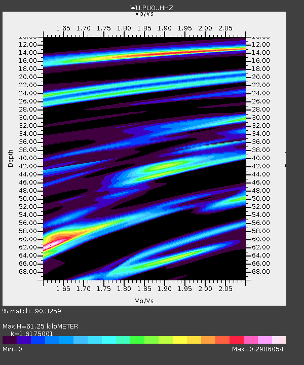
| Estimated Moho Depth: |
61.25 km |
| Estimated Crust Vp/Vs: |
1.62 |
| Assumed Crust Vp: |
6.498 km/s |
| Estimated Crust Vs: |
4.017 km/s |
| Estimated Crust Poisson's Ratio: |
0.19 |
|
| Radial Match: |
90.3259 % |
| Radial Bump: |
251 |
| Transverse Match: |
68.590706 % |
| Transverse Bump: |
400 |
| SOD ConfigId: |
11737051 |
| Insert Time: |
2019-04-25 23:52:17.338 +0000 |
| GWidth: |
2.5 |
| Max Bumps: |
400 |
| Tol: |
0.001 |
|

Signal To Noise
| Channel | StoN | STA | LTA |
| WU:PLIO: :HHZ:20161030T06:50:39.330005Z | 6.1335535 | 1.5612891E-6 | 2.5454887E-7 |
| WU:PLIO: :HHN:20161030T06:50:39.330005Z | 2.2020633 | 5.2758236E-7 | 2.395855E-7 |
| WU:PLIO: :HHE:20161030T06:50:39.330005Z | 2.2654111 | 5.1007186E-7 | 2.2515641E-7 |
| Arrivals |
| Ps | 6.1 SECOND |
| PpPs | 24 SECOND |
| PsPs/PpSs | 30 SECOND |


