You are here: Home > Network List > BK - Berkeley Digital Seismograph Network Stations List
> Station HUMO Hull Mountain, OR > Earthquake Result Viewer
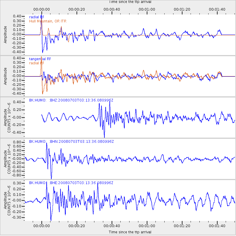
HUMO Hull Mountain, OR - Earthquake Result Viewer
*The percent match for this event was below the threshold and hence no stack was calculated.
| Earthquake location: |
South Of Fiji Islands |
| Earthquake latitude/longitude: |
-23.4/-179.8 |
| Earthquake time(UTC): |
2008/07/03 (185) 03:02:37 GMT |
| Earthquake Depth: |
581 km |
| Earthquake Magnitude: |
5.6 MB, 6.2 MW, 6.2 MW |
| Earthquake Catalog/Contributor: |
WHDF/NEIC |
|
| Network: |
BK Berkeley Digital Seismograph Network |
| Station: |
HUMO Hull Mountain, OR |
| Lat/Lon: |
42.61 N/122.96 W |
| Elevation: |
555 m |
|
| Distance: |
84.0 deg |
| Az: |
38.416 deg |
| Baz: |
230.661 deg |
| Ray Param: |
$rayparam |
*The percent match for this event was below the threshold and hence was not used in the summary stack. |
|
| Radial Match: |
61.484055 % |
| Radial Bump: |
400 |
| Transverse Match: |
60.097557 % |
| Transverse Bump: |
400 |
| SOD ConfigId: |
2504 |
| Insert Time: |
2010-03-05 19:26:22.888 +0000 |
| GWidth: |
2.5 |
| Max Bumps: |
400 |
| Tol: |
0.001 |
|
Signal To Noise
| Channel | StoN | STA | LTA |
| BK:HUMO: :BHN:20080703T03:13:36.080996Z | 4.260563 | 2.747145E-7 | 6.447845E-8 |
| BK:HUMO: :BHE:20080703T03:13:36.080996Z | 2.0674033 | 9.559369E-8 | 4.623853E-8 |
| BK:HUMO: :BHZ:20080703T03:13:36.080996Z | 2.872773 | 1.6153825E-7 | 5.623078E-8 |
| Arrivals |
| Ps | |
| PpPs | |
| PsPs/PpSs | |


