You are here: Home > Network List > US - United States National Seismic Network Stations List
> Station TZTN Tazewell, Tennessee, USA > Earthquake Result Viewer
TZTN Tazewell, Tennessee, USA - Earthquake Result Viewer
| Earthquake location: |
Northern Mid-Atlantic Ridge |
| Earthquake latitude/longitude: |
15.3/-46.0 |
| Earthquake time(UTC): |
2015/09/18 (261) 15:59:42 GMT |
| Earthquake Depth: |
10 km |
| Earthquake Magnitude: |
6.0 MWW, 5.9 MWB, 6.0 MWC |
| Earthquake Catalog/Contributor: |
NEIC PDE/NEIC COMCAT |
|
| Network: |
US United States National Seismic Network |
| Station: |
TZTN Tazewell, Tennessee, USA |
| Lat/Lon: |
36.54 N/83.55 W |
| Elevation: |
394 m |
|
| Distance: |
39.5 deg |
| Az: |
309.524 deg |
| Baz: |
112.418 deg |
| Ray Param: |
0.07493351 |
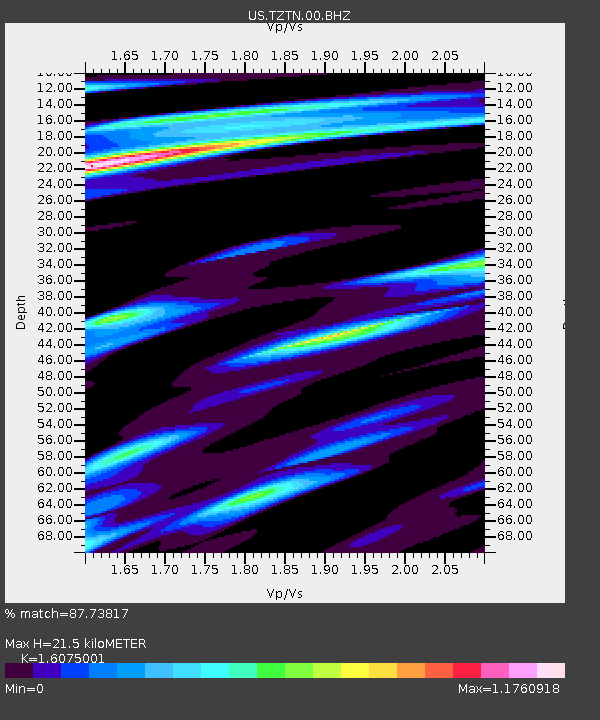
| Estimated Moho Depth: |
21.5 km |
| Estimated Crust Vp/Vs: |
1.61 |
| Assumed Crust Vp: |
6.476 km/s |
| Estimated Crust Vs: |
4.029 km/s |
| Estimated Crust Poisson's Ratio: |
0.18 |
|
| Radial Match: |
87.73817 % |
| Radial Bump: |
380 |
| Transverse Match: |
67.308174 % |
| Transverse Bump: |
400 |
| SOD ConfigId: |
1156111 |
| Insert Time: |
2015-10-24 22:10:02.219 +0000 |
| GWidth: |
2.5 |
| Max Bumps: |
400 |
| Tol: |
0.001 |
|

Signal To Noise
| Channel | StoN | STA | LTA |
| US:TZTN:00:BHZ:20150918T16:06:42.675004Z | 2.9467208 | 4.4198052E-7 | 1.4999063E-7 |
| US:TZTN:00:BH1:20150918T16:06:42.675004Z | 3.8339305 | 2.5074044E-7 | 6.5400364E-8 |
| US:TZTN:00:BH2:20150918T16:06:42.675004Z | 2.6008084 | 1.7034075E-7 | 6.549531E-8 |
| Arrivals |
| Ps | 2.2 SECOND |
| PpPs | 8.0 SECOND |
| PsPs/PpSs | 10 SECOND |


