You are here: Home > Network List > TA - USArray Transportable Network (new EarthScope stations) Stations List
> Station ABTX Abilene, Hawley, TX, USA > Earthquake Result Viewer
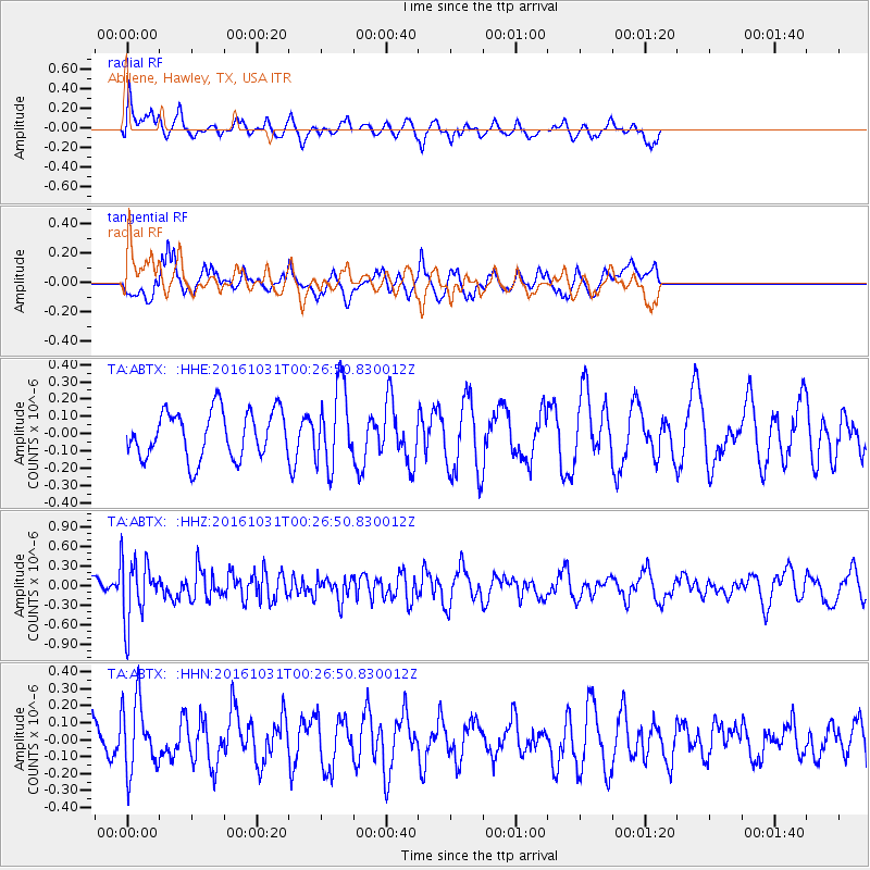
ABTX Abilene, Hawley, TX, USA - Earthquake Result Viewer
*The percent match for this event was below the threshold and hence no stack was calculated.
| Earthquake location: |
Colombia |
| Earthquake latitude/longitude: |
3.4/-74.5 |
| Earthquake time(UTC): |
2016/10/31 (305) 00:20:11 GMT |
| Earthquake Depth: |
33 km |
| Earthquake Magnitude: |
5.6 MWW, 5.4 MWB |
| Earthquake Catalog/Contributor: |
NEIC PDE/NEIC COMCAT |
|
| Network: |
TA USArray Transportable Network (new EarthScope stations) |
| Station: |
ABTX Abilene, Hawley, TX, USA |
| Lat/Lon: |
32.62 N/99.64 W |
| Elevation: |
502 m |
|
| Distance: |
37.4 deg |
| Az: |
323.813 deg |
| Baz: |
135.698 deg |
| Ray Param: |
$rayparam |
*The percent match for this event was below the threshold and hence was not used in the summary stack. |
|
| Radial Match: |
58.14277 % |
| Radial Bump: |
400 |
| Transverse Match: |
81.26791 % |
| Transverse Bump: |
400 |
| SOD ConfigId: |
11737051 |
| Insert Time: |
2019-04-25 23:59:57.984 +0000 |
| GWidth: |
2.5 |
| Max Bumps: |
400 |
| Tol: |
0.001 |
|
Signal To Noise
| Channel | StoN | STA | LTA |
| TA:ABTX: :HHZ:20161031T00:26:50.830012Z | 3.300148 | 4.7365722E-7 | 1.4352607E-7 |
| TA:ABTX: :HHN:20161031T00:26:50.830012Z | 1.645443 | 2.035811E-7 | 1.2372418E-7 |
| TA:ABTX: :HHE:20161031T00:26:50.830012Z | 1.6560358 | 2.2543124E-7 | 1.3612703E-7 |
| Arrivals |
| Ps | |
| PpPs | |
| PsPs/PpSs | |


