You are here: Home > Network List > TA - USArray Transportable Network (new EarthScope stations) Stations List
> Station J26L Joseph Creek, AK, USA > Earthquake Result Viewer
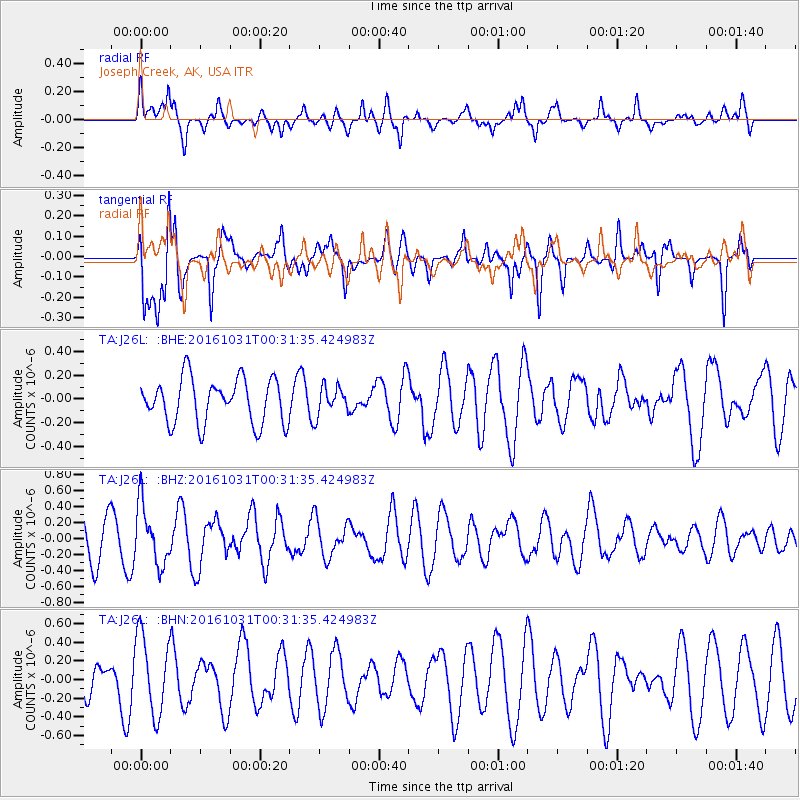
J26L Joseph Creek, AK, USA - Earthquake Result Viewer
*The percent match for this event was below the threshold and hence no stack was calculated.
| Earthquake location: |
Colombia |
| Earthquake latitude/longitude: |
3.4/-74.5 |
| Earthquake time(UTC): |
2016/10/31 (305) 00:20:11 GMT |
| Earthquake Depth: |
33 km |
| Earthquake Magnitude: |
5.6 MWW, 5.4 MWB |
| Earthquake Catalog/Contributor: |
NEIC PDE/NEIC COMCAT |
|
| Network: |
TA USArray Transportable Network (new EarthScope stations) |
| Station: |
J26L Joseph Creek, AK, USA |
| Lat/Lon: |
64.50 N/143.56 W |
| Elevation: |
1144 m |
|
| Distance: |
78.0 deg |
| Az: |
335.586 deg |
| Baz: |
107.597 deg |
| Ray Param: |
$rayparam |
*The percent match for this event was below the threshold and hence was not used in the summary stack. |
|
| Radial Match: |
49.243656 % |
| Radial Bump: |
400 |
| Transverse Match: |
67.71615 % |
| Transverse Bump: |
400 |
| SOD ConfigId: |
11737051 |
| Insert Time: |
2019-04-26 00:00:06.915 +0000 |
| GWidth: |
2.5 |
| Max Bumps: |
400 |
| Tol: |
0.001 |
|
Signal To Noise
| Channel | StoN | STA | LTA |
| TA:J26L: :BHZ:20161031T00:31:35.424983Z | 1.704359 | 3.7766875E-7 | 2.2158989E-7 |
| TA:J26L: :BHN:20161031T00:31:35.424983Z | 2.3189938 | 4.2711446E-7 | 1.8418095E-7 |
| TA:J26L: :BHE:20161031T00:31:35.424983Z | 0.635344 | 1.1952103E-7 | 1.8812018E-7 |
| Arrivals |
| Ps | |
| PpPs | |
| PsPs/PpSs | |


