You are here: Home > Network List > UW - Pacific Northwest Regional Seismic Network Stations List
> Station UMAT Pilot Rock, OR, USA > Earthquake Result Viewer
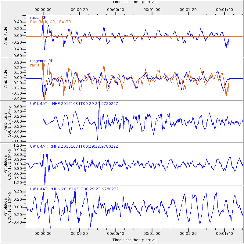
UMAT Pilot Rock, OR, USA - Earthquake Result Viewer
*The percent match for this event was below the threshold and hence no stack was calculated.
| Earthquake location: |
Colombia |
| Earthquake latitude/longitude: |
3.4/-74.5 |
| Earthquake time(UTC): |
2016/10/31 (305) 00:20:11 GMT |
| Earthquake Depth: |
33 km |
| Earthquake Magnitude: |
5.6 MWW, 5.4 MWB |
| Earthquake Catalog/Contributor: |
NEIC PDE/NEIC COMCAT |
|
| Network: |
UW Pacific Northwest Regional Seismic Network |
| Station: |
UMAT Pilot Rock, OR, USA |
| Lat/Lon: |
45.29 N/118.96 W |
| Elevation: |
1318 m |
|
| Distance: |
57.0 deg |
| Az: |
323.862 deg |
| Baz: |
123.491 deg |
| Ray Param: |
$rayparam |
*The percent match for this event was below the threshold and hence was not used in the summary stack. |
|
| Radial Match: |
58.670017 % |
| Radial Bump: |
400 |
| Transverse Match: |
57.899727 % |
| Transverse Bump: |
400 |
| SOD ConfigId: |
11737051 |
| Insert Time: |
2019-04-26 00:01:05.030 +0000 |
| GWidth: |
2.5 |
| Max Bumps: |
400 |
| Tol: |
0.001 |
|
Signal To Noise
| Channel | StoN | STA | LTA |
| UW:UMAT: :HHZ:20161031T00:29:22.978022Z | 2.5988545 | 5.1513763E-7 | 1.9821718E-7 |
| UW:UMAT: :HHN:20161031T00:29:22.978022Z | 1.4465307 | 2.4357243E-7 | 1.6838388E-7 |
| UW:UMAT: :HHE:20161031T00:29:22.978022Z | 1.73117 | 3.5334443E-7 | 2.041073E-7 |
| Arrivals |
| Ps | |
| PpPs | |
| PsPs/PpSs | |


