You are here: Home > Network List > BK - Berkeley Digital Seismograph Network Stations List
> Station HUMO Hull Mountain, OR > Earthquake Result Viewer
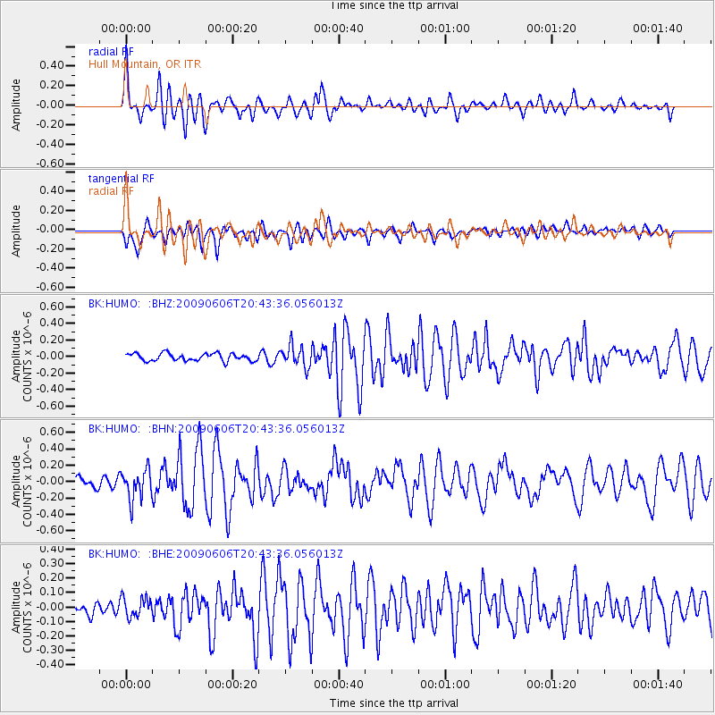
HUMO Hull Mountain, OR - Earthquake Result Viewer
*The percent match for this event was below the threshold and hence no stack was calculated.
| Earthquake location: |
Northern Mid-Atlantic Ridge |
| Earthquake latitude/longitude: |
23.9/-46.1 |
| Earthquake time(UTC): |
2009/06/06 (157) 20:33:28 GMT |
| Earthquake Depth: |
14 km |
| Earthquake Magnitude: |
6.0 MB, 5.7 MS, 6.0 MW, 6.0 MW |
| Earthquake Catalog/Contributor: |
WHDF/NEIC |
|
| Network: |
BK Berkeley Digital Seismograph Network |
| Station: |
HUMO Hull Mountain, OR |
| Lat/Lon: |
42.61 N/122.96 W |
| Elevation: |
555 m |
|
| Distance: |
64.8 deg |
| Az: |
307.415 deg |
| Baz: |
80.041 deg |
| Ray Param: |
$rayparam |
*The percent match for this event was below the threshold and hence was not used in the summary stack. |
|
| Radial Match: |
73.29761 % |
| Radial Bump: |
400 |
| Transverse Match: |
69.47581 % |
| Transverse Bump: |
400 |
| SOD ConfigId: |
2648 |
| Insert Time: |
2010-03-05 19:27:41.438 +0000 |
| GWidth: |
2.5 |
| Max Bumps: |
400 |
| Tol: |
0.001 |
|
Signal To Noise
| Channel | StoN | STA | LTA |
| BK:HUMO: :BHN:20090606T20:43:36.056013Z | 2.6412075 | 1.8304257E-7 | 6.930261E-8 |
| BK:HUMO: :BHE:20090606T20:43:36.056013Z | 1.3164619 | 6.698112E-8 | 5.087965E-8 |
| BK:HUMO: :BHZ:20090606T20:43:36.056013Z | 2.8845308 | 1.2912592E-7 | 4.4764967E-8 |
| Arrivals |
| Ps | |
| PpPs | |
| PsPs/PpSs | |


